IMAGES TAKEN NEAR TO
Netherwitton, MORPETH, NE61 4PS
Introduction
This page details the photographs taken nearby to NE61 4PS by members of the Geograph project.
The Geograph project started in 2005 with the aim of publishing, organising and preserving representative images for every square kilometre of Great Britain, Ireland and the Isle of Man.

There are currently over 7.5m images from over14,400 individuals and you can help contribute to the project by visiting https://www.geograph.org.uk
Image Map
Images are licensed for reuse under creativecommons.org/licenses/by-sa/2.0
Notes
- Clicking on the map will re-center to the selected point.
- The higher the marker number, the further away the image location is from the centre of the postcode.
Image Listing (8 Images Found)
Images are licensed for reuse under creativecommons.org/licenses/by-sa/2.0
Image
Details
Distance
1
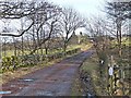
Coldside Farm
Up a drive off the B6342.
Image: © Oliver Dixon
Taken: 8 Feb 2011
0.01 miles
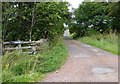
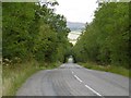
3
Road to Coldside
Short road to the east of the B6342.
Image: © Barbara Carr
Taken: 15 Sep 2013
0.10 miles
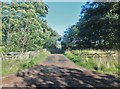
4
Organic Farm
Not sure if this is called Coldside Farm but that's where it is.
Image: © Christine Westerback
Taken: 14 Apr 2006
0.10 miles
6

Old Milestone B6342
On the West side of the road on the verge. Mileage is "Rothbury 4 / Hexham 27"
Grade II listed see https://historicengland.org.uk/listing/the-list/list-entry/1041247
Inscription: R.R / 4 // H / 27
Milestone Society National ID: NB_RBHX04
Image: © Mike Rayner
Taken: 28 Jan 2019
0.13 miles
7
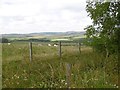
Sheep, Coldside
Burnt a bit of brake rubber to get this one on the cold northern side of a spur with Coldrife at the top. View towards Simonside.
Image: © Richard Webb
Taken: 10 Sep 2015
0.15 miles
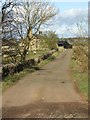
8
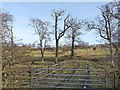
Gateway near Coldside
A shelter belt flanks the east side of the B6342 between Forest Gate and Coldside Farm.
Image: © Oliver Dixon
Taken: 8 Feb 2011
0.24 miles