IMAGES TAKEN NEAR TO
Ewesley, MORPETH, NE61 4PR
Introduction
This page details the photographs taken nearby to NE61 4PR by members of the Geograph project.
The Geograph project started in 2005 with the aim of publishing, organising and preserving representative images for every square kilometre of Great Britain, Ireland and the Isle of Man.

There are currently over 7.5m images from over14,400 individuals and you can help contribute to the project by visiting https://www.geograph.org.uk
Image Map (5 Images)


Getting Data...Please wait
Leaflet Map data © OpenStreetMap
Images are licensed for reuse under creativecommons.org/licenses/by-sa/2.0
Notes
- Clicking on the map will re-center to the selected point.
- The higher the marker number, the further away the image location is from the centre of the postcode.
Image Listing (5 Images Found)
Images are licensed for reuse under creativecommons.org/licenses/by-sa/2.0
Image
Details
Distance
1
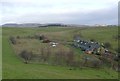
Fontburn Halt
On the old Northumberland Central Railway.
The railway continued north around Garleigh Moor to Rothbury.
Image: © Russel Wills
Taken: 23 Jan 2016
0.01 miles
2
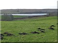
Moles in pasture
With Fontburn Reservoir in the background.
Image: © Russel Wills
Taken: 23 Jan 2016
0.11 miles
3
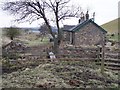
Disused railway halt at Fontburn, Northumberland
Although there was no village for miles the Northumberland Central Railway built a station at Fontburn 6½ miles south of Rothbury. It was mainly used by workers at the nearby Whitehouse Colliery and lime kilns. From 1890 it would also have been used by men working on the new Fontburn Reservoir. In 1921 it was reduced in status to a halt. It is now a private residence.
Image: © Ralph Rawlinson
Taken: 5 Feb 2006
0.14 miles
4
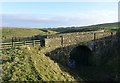
A bridge over the old Northumberland Central Railway
Carrying a track from Ritton White House to Newbiggin Farm.
Image: © Russel Wills
Taken: 23 Jan 2016
0.15 miles
5
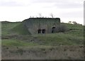
Lime kiln below the Whitehouse Quarries
Viewed from the track-bed of the old Northumberland Central Railway.
The right hand kiln was built c.1860, the left hand one in 1883 after an expansion of the Whitehouse Quarries. It last burnt lime in 1924, although from c.1904 this was on a fairly intermittent basis. Both kilns are Grade 2 Listed.
Image: © Russel Wills
Taken: 23 Jan 2016
0.19 miles