IMAGES TAKEN NEAR TO
Hartburn, MORPETH, NE61 4JE
Introduction
This page details the photographs taken nearby to NE61 4JE by members of the Geograph project.
The Geograph project started in 2005 with the aim of publishing, organising and preserving representative images for every square kilometre of Great Britain, Ireland and the Isle of Man.

There are currently over 7.5m images from over14,400 individuals and you can help contribute to the project by visiting https://www.geograph.org.uk
Image Map (7 Images)


Getting Data...Please wait
Leaflet Map data © OpenStreetMap
Images are licensed for reuse under creativecommons.org/licenses/by-sa/2.0
Notes
- Clicking on the map will re-center to the selected point.
- The higher the marker number, the further away the image location is from the centre of the postcode.
Image Listing (7 Images Found)
Images are licensed for reuse under creativecommons.org/licenses/by-sa/2.0
Image
Details
Distance
1
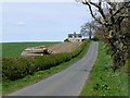
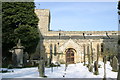
Thornton House Cottage
With timber production as well as farming in evidence.
Image: © Russel Wills
Taken: 27 Apr 2015
0.01 miles
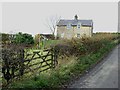
5
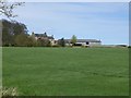
Thornton House
Large farm at the top of the hill.
Image: © Russel Wills
Taken: 27 Apr 2015
0.09 miles
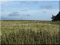
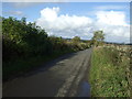
7
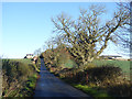
The road to Thornton Moor
Thornton House Cottage on the left; some of the farm buildings of Thornton House Farm can be seen to the right.
Image: © Oliver Dixon
Taken: 2 Nov 2015
0.15 miles