IMAGES TAKEN NEAR TO
Middleton, MORPETH, NE61 4EA
Introduction
This page details the photographs taken nearby to NE61 4EA by members of the Geograph project.
The Geograph project started in 2005 with the aim of publishing, organising and preserving representative images for every square kilometre of Great Britain, Ireland and the Isle of Man.

There are currently over 7.5m images from over14,400 individuals and you can help contribute to the project by visiting https://www.geograph.org.uk
Image Map (Loading...)


Getting Data...Please wait
Leaflet Map data © OpenStreetMap
Images are licensed for reuse under creativecommons.org/licenses/by-sa/2.0
Notes
- Clicking on the map will re-center to the selected point.
- The higher the marker number, the further away the image location is from the centre of the postcode.
Image Listing (18 Images Found)
Images are licensed for reuse under creativecommons.org/licenses/by-sa/2.0
Image
Details
Distance
2
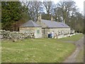
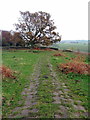
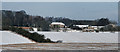
Track west of East Shaftoe Hall
East Shaftoe farm cottages are on the left and the walled garden on the right beyond low earthwork remains of the deserted medieval village of East Shaftoe.
Image: © Andrew Curtis
Taken: 31 Oct 2014
0.01 miles
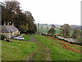
5
Cobbled track down from Shaftoe Crags
The track is steeply cambered from its centre. There is another photo here Image
Close to this location are the remains of a pre-1378 chapel and its burial ground.
It is likely that this was the original location of the engraved tombstone referred to in the discussion post http://www.geograph.org.uk/discuss/index.php?gridref=NZ0581
Image: © Andrew Curtis
Taken: 31 Oct 2014
0.07 miles
6
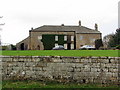
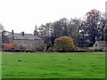
East Shaftoe Hall
East Shaftoe Hall is a Grade I Listed Building. It is composed of a medieval tower house of the late C13th or C14th to left with later house, possible C16th but altered later, attached to right. The interior has clues that the house was once a full 3 storeys. There is a C19th lean-to carriage house on left.
Image: © Andrew Curtis
Taken: 31 Oct 2014
0.12 miles
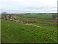
8
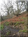
Spring near East Shaftoe Hall
It is a spring, but it's not a particccularly pretty one! A very small stream issues from it and forms another boggy pool some 20 yards downhill.
Image: © Leanmeanmo
Taken: 27 Jan 2017
0.13 miles
9
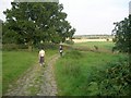
East Shaftoe Hall
East Shaftoe Hall Farm seen from the A696.
Image: © Peter McDermott
Taken: 22 Dec 2009
0.13 miles
10
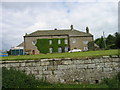
East Shaftoe Hall
Keys to the Past Web Site: A late 13th or 14th century tower forms the earliest part of East Shaftoe Hall. It stands at the west end of a 16th century house which has 17th and 18th century alterations. The tower has walls up to 1.3m thick and in the basement there is a barrel vault. The early 16th century house seems to have been altered later that century into an 'H' strong house. In the 17th century it was altered again and became a more conventional house, and in the 18th century quite drastic alterations were made. These entailed reducing the height in some areas and heightening others and replacing all the mullioned windows with sash windows.
Image: © Les Hull
Taken: 9 Jun 2005
0.14 miles