IMAGES TAKEN NEAR TO
MORPETH, NE61 3YJ
Introduction
This page details the photographs taken nearby to NE61 3YJ by members of the Geograph project.
The Geograph project started in 2005 with the aim of publishing, organising and preserving representative images for every square kilometre of Great Britain, Ireland and the Isle of Man.

There are currently over 7.5m images from over14,400 individuals and you can help contribute to the project by visiting https://www.geograph.org.uk
Image Map (Loading...)


Getting Data...Please wait
Leaflet Map data © OpenStreetMap
Images are licensed for reuse under creativecommons.org/licenses/by-sa/2.0
Notes
- Clicking on the map will re-center to the selected point.
- The higher the marker number, the further away the image location is from the centre of the postcode.
Image Listing (8 Images Found)
Images are licensed for reuse under creativecommons.org/licenses/by-sa/2.0
Image
Details
Distance
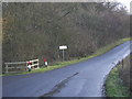
2
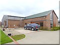
The Gubeon Coffee Shop
This somewhat anonymous looking building does in fact house an excellent coffee shop on the first floor. Part of the Gubeon Equestrian Centre, established in 2010.
Image: © Oliver Dixon
Taken: 24 Apr 2018
0.03 miles
5
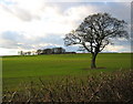
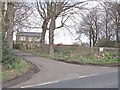
Field and tree
Looking towards Gubeon Farm (or "The Gubeon" as the 1" maps call it) from the Commongate Plantation...nice of the farmer to have kept the tree!
Image: © Alan Fearon
Taken: 8 Feb 2006
0.07 miles
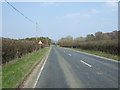
8

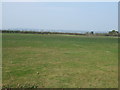
Farmland near Gubeon Golf Course
Off the B6524.
Image: © JThomas
Taken: 9 Apr 2015
0.22 miles