IMAGES TAKEN NEAR TO
Whalton, MORPETH, NE61 3TS
Introduction
This page details the photographs taken nearby to NE61 3TS by members of the Geograph project.
The Geograph project started in 2005 with the aim of publishing, organising and preserving representative images for every square kilometre of Great Britain, Ireland and the Isle of Man.

There are currently over 7.5m images from over14,400 individuals and you can help contribute to the project by visiting https://www.geograph.org.uk
Image Map (Loading...)


Getting Data...Please wait
Leaflet Map data © OpenStreetMap
Images are licensed for reuse under creativecommons.org/licenses/by-sa/2.0
Notes
- Clicking on the map will re-center to the selected point.
- The higher the marker number, the further away the image location is from the centre of the postcode.
Image Listing (8 Images Found)
Images are licensed for reuse under creativecommons.org/licenses/by-sa/2.0
Image
Details
Distance
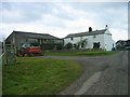
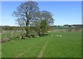
2
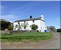
Howlett Hall
Beside the open to all traffic byway to Low Angerton.
Image: © Russel Wills
Taken: 27 Apr 2015
0.02 miles
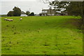
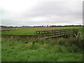
4
An open to all traffic byway!
The tarmacked road to Howlett Hall seemed to end in a farmyard. A helpful local resident pointed the way across this field and opened the first gate for me!
Image: © Russel Wills
Taken: 27 Apr 2015
0.05 miles
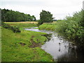
6
Footbridge over Wansbeck
A relief to see this bridge, not marked on map
Image: © Black Dog
Taken: 22 Aug 2007
0.17 miles
7
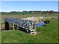
Footbridge over River Wansbeck
Near Howlett Hall.
Image: © Russel Wills
Taken: 27 Apr 2015
0.17 miles