IMAGES TAKEN NEAR TO
Tailor Way, MORPETH, NE61 2ZJ
Introduction
This page details the photographs taken nearby to Tailor Way, NE61 2ZJ by members of the Geograph project.
The Geograph project started in 2005 with the aim of publishing, organising and preserving representative images for every square kilometre of Great Britain, Ireland and the Isle of Man.

There are currently over 7.5m images from over14,400 individuals and you can help contribute to the project by visiting https://www.geograph.org.uk
Image Map
Images are licensed for reuse under creativecommons.org/licenses/by-sa/2.0
Notes
- Clicking on the map will re-center to the selected point.
- The higher the marker number, the further away the image location is from the centre of the postcode.
Image Listing (7 Images Found)
Images are licensed for reuse under creativecommons.org/licenses/by-sa/2.0
Image
Details
Distance
1

Broom Close
In Stobhillgate, a suburb of Morpeth.
Image: © Russel Wills
Taken: 11 May 2015
0.09 miles
2

Bus stop with cherry blossom
On the road to Ashington.
Image: © Russel Wills
Taken: 11 May 2015
0.10 miles
3
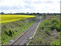
Railway heading towards Blyth
Past the oil seed rape in full flower.
Image: © Russel Wills
Taken: 11 May 2015
0.14 miles
4
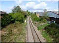
Railway line heading towards Morpeth Station
Judging by the rusty lines - not much used.
Image: © Russel Wills
Taken: 11 May 2015
0.17 miles
7

Garage, Coopies Lane Industrial Estate, Morpeth
A branch of the ATS Euromaster garage business on Coopies Lane estate in Morpeth.
Image: © Graham Robson
Taken: 12 Nov 2016
0.22 miles