IMAGES TAKEN NEAR TO
MORPETH, NE61 2YJ
Introduction
This page details the photographs taken nearby to NE61 2YJ by members of the Geograph project.
The Geograph project started in 2005 with the aim of publishing, organising and preserving representative images for every square kilometre of Great Britain, Ireland and the Isle of Man.

There are currently over 7.5m images from over14,400 individuals and you can help contribute to the project by visiting https://www.geograph.org.uk
Image Map (Loading...)


Getting Data...Please wait
Leaflet Map data © OpenStreetMap
Images are licensed for reuse under creativecommons.org/licenses/by-sa/2.0
Notes
- Clicking on the map will re-center to the selected point.
- The higher the marker number, the further away the image location is from the centre of the postcode.
Image Listing (32 Images Found)
Images are licensed for reuse under creativecommons.org/licenses/by-sa/2.0
Image
Details
Distance
1
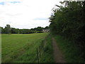
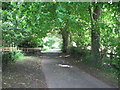
Public footpath near Morpeth
A bit over-grown at this point but still well used.
Image: © Willie Duffin
Taken: 22 Jul 2012
0.01 miles
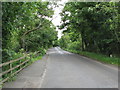
3
View along B6343
Looking in a westerly direction.
Image: © Willie Duffin
Taken: 22 Jul 2012
0.10 miles
4
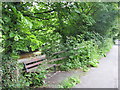
Wooden seat on the B6343
A welcome sight for the weary foot traveler with a nice view of the river to the rear.
Image: © Willie Duffin
Taken: 22 Jul 2012
0.10 miles
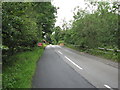
5
Minor road near Lowford Bridge
This road gradually narrows to becomes a public footpath.
Image: © Willie Duffin
Taken: 22 Jul 2012
0.11 miles
6
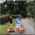
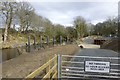
Temporary lights, B6343
The road between Morpeth and Mitford is being investigated for damage from the River Wansbeck (right). There was a long wait.
Image: © Richard Webb
Taken: 26 Aug 2024
0.12 miles
7
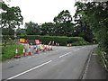
Road works on B6343
Road works at a junction with a minor side road.
Image: © Willie Duffin
Taken: 22 Jul 2012
0.13 miles
9
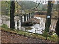
Giant 'comb' in action
Collecting logs and debris in the aftermath of Storm Arwen this structure on the Wansbeck, designed to protect Morpeth bridges etc., appears to be doing its job effectively.
Image: © Leanmeanmo
Taken: 6 Dec 2021
0.15 miles
10
Debris poles designed to catch trees
The Flood Risk team says these are debris poles, designed to catch trees, branches and other debris during a flood. This is to prevent the bridges getting blocked and causing flooding to the town of Morpeth. They are one part of the Morpeth Flood Alleviation Scheme.
See also: http://www.geograph.org.uk/photo/5315375 http://www.geograph.org.uk/photo/4412828
Image: © Russel Wills
Taken: 16 Mar 2017
0.15 miles