IMAGES TAKEN NEAR TO
Lindisfarne Lane, MORPETH, NE61 2UL
Introduction
This page details the photographs taken nearby to Lindisfarne Lane, NE61 2UL by members of the Geograph project.
The Geograph project started in 2005 with the aim of publishing, organising and preserving representative images for every square kilometre of Great Britain, Ireland and the Isle of Man.

There are currently over 7.5m images from over14,400 individuals and you can help contribute to the project by visiting https://www.geograph.org.uk
Image Map
Images are licensed for reuse under creativecommons.org/licenses/by-sa/2.0
Notes
- Clicking on the map will re-center to the selected point.
- The higher the marker number, the further away the image location is from the centre of the postcode.
Image Listing (13 Images Found)
Images are licensed for reuse under creativecommons.org/licenses/by-sa/2.0
Image
Details
Distance
1
View from a Newcastle-Edinburgh train - Stobhill, Morpeth
Image: © Nigel Thompson
Taken: 11 May 2016
0.17 miles
2

Fire and Rescue HQ
Near County Hall in Morpeth
Image: © David Clark
Taken: 26 Jan 2010
0.17 miles
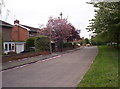
3

Stobhill Social Club
A social club on the busy junction of the A192 and A196.
Image: © Weston Beggard
Taken: 13 May 2006
0.17 miles
4
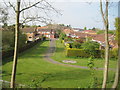
Whinham Way
Modern housing development in Stobhill.
Image: © Weston Beggard
Taken: 13 May 2006
0.17 miles
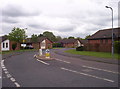
5
High Stobhill
Quiet residential street in Stobhill.
Image: © Weston Beggard
Taken: 13 May 2006
0.17 miles
6

County Hall Morpeth
Northumberland County Council Headquarters at Morpeth
Image: © george hurrell
Taken: 6 Jan 2007
0.17 miles

8

Decorative planter
Outside Morpeth Fire and Rescue HQ
Image: © David Clark
Taken: 26 Jan 2010
0.18 miles

10
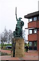
Statue of a Viking Warrior at County Hall
For more info re: the statue
http://vads.ahds.ac.uk/large.php?uid=75121
Image: © David Clark
Taken: 26 Jan 2010
0.20 miles