IMAGES TAKEN NEAR TO
Felton Close, MORPETH, NE61 2TG
Introduction
This page details the photographs taken nearby to Felton Close, NE61 2TG by members of the Geograph project.
The Geograph project started in 2005 with the aim of publishing, organising and preserving representative images for every square kilometre of Great Britain, Ireland and the Isle of Man.

There are currently over 7.5m images from over14,400 individuals and you can help contribute to the project by visiting https://www.geograph.org.uk
Image Map (Loading...)


Getting Data...Please wait
Leaflet Map data © OpenStreetMap
Images are licensed for reuse under creativecommons.org/licenses/by-sa/2.0
Notes
- Clicking on the map will re-center to the selected point.
- The higher the marker number, the further away the image location is from the centre of the postcode.
Image Listing (11 Images Found)
Images are licensed for reuse under creativecommons.org/licenses/by-sa/2.0
Image
Details
Distance
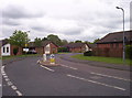
1

Stobhill Social Club
A social club on the busy junction of the A192 and A196.
Image: © Weston Beggard
Taken: 13 May 2006
0.07 miles
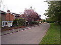
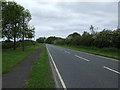
2
Whinham Way
Modern housing development in Stobhill.
Image: © Weston Beggard
Taken: 13 May 2006
0.07 miles
3
High Stobhill
Quiet residential street in Stobhill.
Image: © Weston Beggard
Taken: 13 May 2006
0.07 miles
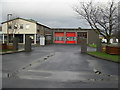
4

County Hall Morpeth
Northumberland County Council Headquarters at Morpeth
Image: © george hurrell
Taken: 6 Jan 2007
0.07 miles
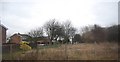
7
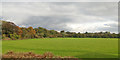
Field south of Stobhill
The higher trees on the left are along the Catch Burn.
Image: © Robin Webster
Taken: 18 Oct 2019
0.18 miles

10
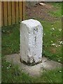
Old Milestone by Turner Square, Morpeth
Carved stone post by the UC road, in parish of HEPSCOTT (CASTLE MORPETH District), Turner Square, Morpeth, on grass verge, on West side of road. Erected by the Shields & Morpeth & Branches turnpike trust in the 19th century.
Inscription reads:-
M
1
Northumberland HER listed.
Reference number: N27116 https://www.heritagegateway.org.uk/Gateway/Results_Single.aspx?uid=N27116&resourceID=110
Milestone Society National ID: NB_MPCP01.
Image: © M Rayner
Taken: 3 Jun 2016
0.21 miles