IMAGES TAKEN NEAR TO
Shields Road, MORPETH, NE61 2SB
Introduction
This page details the photographs taken nearby to Shields Road, NE61 2SB by members of the Geograph project.
The Geograph project started in 2005 with the aim of publishing, organising and preserving representative images for every square kilometre of Great Britain, Ireland and the Isle of Man.

There are currently over 7.5m images from over14,400 individuals and you can help contribute to the project by visiting https://www.geograph.org.uk
Image Map (Loading...)


Getting Data...Please wait
Leaflet Map data © OpenStreetMap
Images are licensed for reuse under creativecommons.org/licenses/by-sa/2.0
Notes
- Clicking on the map will re-center to the selected point.
- The higher the marker number, the further away the image location is from the centre of the postcode.
Image Listing (43 Images Found)
Images are licensed for reuse under creativecommons.org/licenses/by-sa/2.0
Image
Details
Distance
1
St Aidan's Church, Stobhill, Morpeth
Image: © Bill Henderson
Taken: 10 Jun 2012
0.03 miles
2
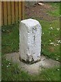
Old Milestone by Turner Square, Morpeth
Carved stone post by the UC road, in parish of HEPSCOTT (CASTLE MORPETH District), Turner Square, Morpeth, on grass verge, on West side of road. Erected by the Shields & Morpeth & Branches turnpike trust in the 19th century.
Inscription reads:-
M
1
Northumberland HER listed.
Reference number: N27116 https://www.heritagegateway.org.uk/Gateway/Results_Single.aspx?uid=N27116&resourceID=110
Milestone Society National ID: NB_MPCP01.
Image: © M Rayner
Taken: 3 Jun 2016
0.21 miles
3
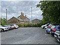
Morpeth B&T railway station (site), Northumberland
Opened in 1856 by the Blyth & Tyne Railway, later part of the North Eastern Railway, this station was the terminus of the line from Newcastle via Backworth and Bedlington. It closed to passengers in 1880 when trains were transferred to the current Morpeth station, just out of view to the far left of this image (see also Image), but was still open for goods into the 1980s. The station buildings were then converted to private residential use.
View east from the buffers towards Hepscott and Bedlington.
For more information, see http://www.disused-stations.org.uk/m/morpeth/index.shtml
Image: © Nigel Thompson
Taken: 9 Jun 2022
0.21 miles
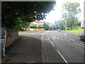
4
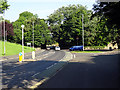
Shields Road, Morpeth
The entrance to the station is on the right. The rail overbridge of the East Coast Main Line is just visible in the trees.
Image: © John Lucas
Taken: 16 Aug 2016
0.21 miles
5
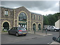
Green Country Store, Morpeth
Housed in converted railway buildings this shop sells agricultural and garden supplies.
Image: © Willie Duffin
Taken: 19 Jul 2012
0.21 miles
6
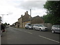
Coopies Lane, Morpeth
Former railway buildings near Morpeth railway station.
Image: © Willie Duffin
Taken: 19 Jul 2012
0.22 miles
8
Road junction, Morpeth
The junction of Coopies Lane and the A197.
Image: © Willie Duffin
Taken: 19 Jul 2012
0.22 miles
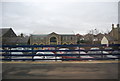
9
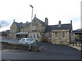
Morpeth Station
The main station building at Morpeth Railway Station. The station is served by trains travelling on the East Coast Mainline including fast trains between Newcastle and Edinburgh and local services from Newcastle, some of which terminate at Morpeth.
Image: © Graham Robson
Taken: 12 Nov 2016
0.23 miles
10
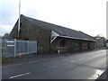
Former goods shed at Morpeth Station
The former goods shed stands on Coopies Lane beside the East Coast Mainline.
Image: © Graham Robson
Taken: 12 Nov 2016
0.23 miles