IMAGES TAKEN NEAR TO
St. Marys Field, MORPETH, NE61 2QA
Introduction
This page details the photographs taken nearby to St. Marys Field, NE61 2QA by members of the Geograph project.
The Geograph project started in 2005 with the aim of publishing, organising and preserving representative images for every square kilometre of Great Britain, Ireland and the Isle of Man.

There are currently over 7.5m images from over14,400 individuals and you can help contribute to the project by visiting https://www.geograph.org.uk
Image Map
Images are licensed for reuse under creativecommons.org/licenses/by-sa/2.0
Notes
- Clicking on the map will re-center to the selected point.
- The higher the marker number, the further away the image location is from the centre of the postcode.
Image Listing (65 Images Found)
Images are licensed for reuse under creativecommons.org/licenses/by-sa/2.0
Image
Details
Distance
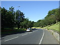
1
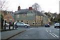
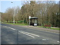
Bus stop on the A197
Heading into Morpeth centre.
Image: © JThomas
Taken: 9 Apr 2015
0.05 miles
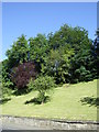
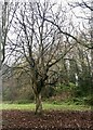
2
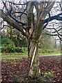
Helical structure of Horse Chestnut exposed
Maybe a victim of this summer's drought.
Image: © Leanmeanmo
Taken: 1 Dec 2022
0.06 miles
4
Helical structure of Horse Chestnut exposed
Maybe a victim of this summer's drought.
Image: © Leanmeanmo
Taken: 1 Dec 2022
0.07 miles