IMAGES TAKEN NEAR TO
Castle Walk, MORPETH, NE61 2PW
Introduction
This page details the photographs taken nearby to Castle Walk, NE61 2PW by members of the Geograph project.
The Geograph project started in 2005 with the aim of publishing, organising and preserving representative images for every square kilometre of Great Britain, Ireland and the Isle of Man.

There are currently over 7.5m images from over14,400 individuals and you can help contribute to the project by visiting https://www.geograph.org.uk
Image Map
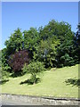
Images are licensed for reuse under creativecommons.org/licenses/by-sa/2.0
Notes
- Clicking on the map will re-center to the selected point.
- The higher the marker number, the further away the image location is from the centre of the postcode.
Image Listing (168 Images Found)
Images are licensed for reuse under creativecommons.org/licenses/by-sa/2.0
Image
Details
Distance
3
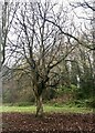
Helical structure of Horse Chestnut exposed
Maybe a victim of this summer's drought.
Image: © Leanmeanmo
Taken: 1 Dec 2022
0.07 miles
4
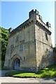
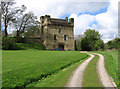
Remains of Morpeth Castle
Located in Carlisle Park.
Image: © DS Pugh
Taken: 4 Jul 2015
0.08 miles
5
Morpeth - Castle
For an alternative view, please see Image
Image: © Dave Bevis
Taken: 28 Apr 2012
0.08 miles
6
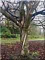
Helical structure of Horse Chestnut exposed
Maybe a victim of this summer's drought.
Image: © Leanmeanmo
Taken: 1 Dec 2022
0.09 miles
7
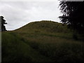
Haw Hill
The site of the earlier of Morpeth's castles.
Image: © Stuart Shepherd
Taken: 24 Jul 2015
0.11 miles
8
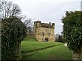
Morpeth Castle
A perfect Holiday home, that is what its use is now.
Image: © Sarah Clark
Taken: 7 Apr 2010
0.11 miles
9
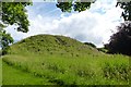
Morpeth motte
Looking at the site of the old castle.
Image: © DS Pugh
Taken: 4 Jul 2015
0.12 miles
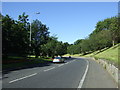
10
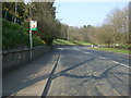
Bus stop on the A197
Heading into Morpeth centre.
Image: © JThomas
Taken: 9 Apr 2015
0.12 miles