IMAGES TAKEN NEAR TO
Fontburn Gardens, MORPETH, NE61 2JR
Introduction
This page details the photographs taken nearby to Fontburn Gardens, NE61 2JR by members of the Geograph project.
The Geograph project started in 2005 with the aim of publishing, organising and preserving representative images for every square kilometre of Great Britain, Ireland and the Isle of Man.

There are currently over 7.5m images from over14,400 individuals and you can help contribute to the project by visiting https://www.geograph.org.uk
Image Map (Loading...)


Getting Data...Please wait
Leaflet Map data © OpenStreetMap
Images are licensed for reuse under creativecommons.org/licenses/by-sa/2.0
Notes
- Clicking on the map will re-center to the selected point.
- The higher the marker number, the further away the image location is from the centre of the postcode.
Image Listing (12 Images Found)
Images are licensed for reuse under creativecommons.org/licenses/by-sa/2.0
Image
Details
Distance
1
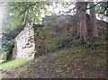
Castle Walls
Ruins of Morpeth's motte-and-bailey castle.
Image: © Weston Beggard
Taken: 19 Aug 2006
0.16 miles
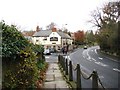
2
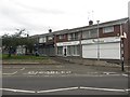
Row of local shops, Abbeyfields, Morpeth
A row of local shops in a residential area west of Morpeth town centre.
Image: © Graham Robson
Taken: 3 Jul 2016
0.16 miles
3
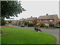
Church Walk, Morpeth
A street lined with semi detached houses to the west of Morpeth town centre.
Image: © Graham Robson
Taken: 3 Jul 2016
0.23 miles
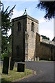
7
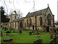
The Church of St Mary the Virgin, Morpeth
Image: © Bill Henderson
Taken: 14 Nov 2007
0.24 miles
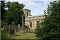
8
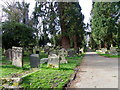
Churchyard, St Mary's Church
The churchyard contains burials from many generations, showing the Church's concern for its parishioners in this life and beyond the grave. The stones tell the history of the Parish and reflect changing attitudes and fashions.
Image: © Maigheach-gheal
Taken: 7 Apr 2011
0.24 miles
9
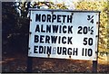
Old Sign board by the B1337,
Sign board by the B1337 (was A1 and then A197), in parish of Morpeth (Castle Morpeth District), junction with St Mary's Road, in flower beds behind footpath.
Surveyed
Milestone Society National ID: NB_NCMP14
Image: © Milestone Society
Taken: Unknown
0.24 miles