
IMAGES TAKEN NEAR TO
Blackett Court, MORPETH, NE61 2FF
Introduction
This page details the photographs taken nearby to Blackett Court, NE61 2FF by members of the Geograph project.
The Geograph project started in 2005 with the aim of publishing, organising and preserving representative images for every square kilometre of Great Britain, Ireland and the Isle of Man.

There are currently over 7.5m images from over14,400 individuals and you can help contribute to the project by visiting https://www.geograph.org.uk
Image Map
Images are licensed for reuse under creativecommons.org/licenses/by-sa/2.0
Notes
- Clicking on the map will re-center to the selected point.
- The higher the marker number, the further away the image location is from the centre of the postcode.
Image Listing (4 Images Found)
Images are licensed for reuse under creativecommons.org/licenses/by-sa/2.0
Image
Details
Distance
1
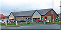
Co-op supermarket, Loansdean, Morpeth
A small supermarket at the turning into fairly modern development.
Image: © Robin Webster
Taken: 23 Dec 2019
0.15 miles
2

Road leaving Morpeth southwards
Once the A1.
Image: © Richard Webb
Taken: 21 Aug 2025
0.17 miles
3
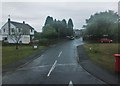
The Fairway, Loansdean
Leading to Long Drive, The Chip and The Turn; photographed on a mizzly day in early September.
Image: © Barbara Carr
Taken: 6 Sep 2013
0.19 miles
4
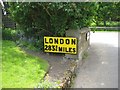
Modern Milepost by the B1337, Catchburn, Morpeth
Milepost by the B1337, in parish of Hepscott (Castle Morpeth District), Catchburn, Morpeth, on farmyard wall - cannot be seen from road as is round the corner of drive wall.
Inscription reads:-
LONDON
283¾ MILES
Surveyed
Milestone Society National ID: NB_NCMP13a
Image: © M Rayner
Taken: Unknown
0.22 miles