IMAGES TAKEN NEAR TO
The Chip, MORPETH, NE61 2DR
Introduction
This page details the photographs taken nearby to The Chip, NE61 2DR by members of the Geograph project.
The Geograph project started in 2005 with the aim of publishing, organising and preserving representative images for every square kilometre of Great Britain, Ireland and the Isle of Man.

There are currently over 7.5m images from over14,400 individuals and you can help contribute to the project by visiting https://www.geograph.org.uk
Image Map
Images are licensed for reuse under creativecommons.org/licenses/by-sa/2.0
Notes
- Clicking on the map will re-center to the selected point.
- The higher the marker number, the further away the image location is from the centre of the postcode.
Image Listing (7 Images Found)
Images are licensed for reuse under creativecommons.org/licenses/by-sa/2.0
Image
Details
Distance
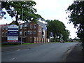
1
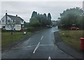
The Fairway, Loansdean
Leading to Long Drive, The Chip and The Turn; photographed on a mizzly day in early September.
Image: © Barbara Carr
Taken: 6 Sep 2013
0.08 miles
2
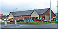
Co-op supermarket, Loansdean, Morpeth
A small supermarket at the turning into fairly modern development.
Image: © Robin Webster
Taken: 23 Dec 2019
0.10 miles
3
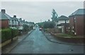
The Avenue, Loansdean
On miserable day in early September.
Image: © Barbara Carr
Taken: 6 Sep 2013
0.16 miles
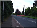
5

Parking at a premium?
A full car park in front of these commercial premises at Telford Court, a relatively new business park development
Image: © David Clark
Taken: 26 Jan 2010
0.19 miles
6
The Kylins
Site of a new housing development.
Image: © JThomas
Taken: 28 Jul 2012
0.23 miles
7
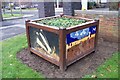
Decorative planter
Outside Morpeth Fire and Rescue HQ
Image: © David Clark
Taken: 26 Jan 2010
0.24 miles