IMAGES TAKEN NEAR TO
Newminster Terrace, MORPETH, NE61 1DB
Introduction
This page details the photographs taken nearby to Newminster Terrace, NE61 1DB by members of the Geograph project.
The Geograph project started in 2005 with the aim of publishing, organising and preserving representative images for every square kilometre of Great Britain, Ireland and the Isle of Man.

There are currently over 7.5m images from over14,400 individuals and you can help contribute to the project by visiting https://www.geograph.org.uk
Image Map (Loading...)


Getting Data...Please wait
Leaflet Map data © OpenStreetMap
Images are licensed for reuse under creativecommons.org/licenses/by-sa/2.0
Notes
- Clicking on the map will re-center to the selected point.
- The higher the marker number, the further away the image location is from the centre of the postcode.
Image Listing (108 Images Found)
Images are licensed for reuse under creativecommons.org/licenses/by-sa/2.0
Image
Details
Distance
1
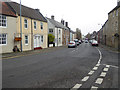
Newgate Street, Morpeth
Carrying the A192 from the A1 southbound into Morpeth town centre.
Image: © Oliver Dixon
Taken: 2 Nov 2015
0.01 miles
2
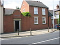
Hampton Court House, Morpeth
Situated on the A192.
Image: © Willie Duffin
Taken: 22 Jul 2012
0.01 miles
3
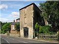
Bricked-up windows, Morpeth
An oddly shaped building at the start of the B6343 road to Mitford. It looks as if it may have been used for some form of industry.
Image: © Willie Duffin
Taken: 22 Jul 2012
0.04 miles
4
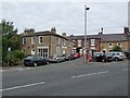
Bullers Green
Off Newgate Street, this "green" is now paved over to provide car parking space.
Image: © Oliver Dixon
Taken: 13 Jul 2011
0.04 miles
5

Mount Pleasant Cottage
Modern conversion or addition to the older building in the background.
Image: © Willie Duffin
Taken: 22 Jul 2012
0.04 miles
7
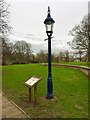
Joseph Webb Sewer Gas Destructor Lamp
This was no ordinary gas lamp, this was Victorian engineering at its finest, and recycling well ahead of its time. Very few examples of these lamps remain, designed to draw foul gases from the sewers and burn them off, thereby not only eradicating the smell, but also providing additional light. This is probably the most northerly example of its kind. It has been converted to electrical power and has lost part of one of its ladder bars. For an excellent view of the lantern of one of these lamps see
Image
See also
https://www.thenorthernecho.co.uk/history/3558291.raising-stink/
https://www.xenophon.org.uk/webbsewerlamp.html
Image: © Leanmeanmo
Taken: 19 Feb 2020
0.06 miles
8
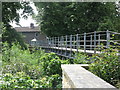
High Stanners Bridge, Morpeth
When the first Ordnance Survey Six-Inch map of the area was published in 1866 there was no footbridge crossing of the River Wansbeck at this point. However, by the time of the publication of the second edition of the map in 1898, a footbridge had been built here. The bridge is now part of a designated public footpath.
Image: © Geoff Holland
Taken: 2 Jul 2020
0.06 miles
9
B6343 looking Northeast
Looking along the Mitford Road.
Image: © Willie Duffin
Taken: 22 Jul 2012
0.06 miles
10
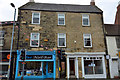
53 and 55, Newgate Street, Morpeth
53 and 55 Newgate Street, Morpeth currently occupied by Blue Nail Bar and Ryecroft Glenton.
Both are Grade II Listed, this is the listing text:
Description: 53 and 55, Newgate Street
Grade: II
Date Listed: 22 August 1986
English Heritage Building ID: 238754
OS Grid Reference: NZ1974286155
OS Grid Coordinates: 419742, 586155
Latitude/Longitude: 55.1693, -1.6916
Location: 51 Newgate Street, Morpeth, Northumberland NE61 1AT
Locality: Morpeth
County: Northumberland
Country: England
Postcode: NE61 1AT
MORPETH NEWGATE STREET (West side) Nos. 53 and 55
NZ 1986
22/265
GV II
2 houses, now offices. C18, remodelled early C19.
Dressed stone, brick to rear. Welsh slate roof. 3 storeys, 3 bays. Central round-arched entry to passage through to rear of building. Flanking early C20 shop fronts. 2-pane sashes with projecting sills. Gabled roof with flat coping and brick end stacks. 2-storey rear wing with 12-pane sashes.
Listing NGR: NZ1974286155
Image: © Steve Ellwood
Taken: 21 Sep 2016
0.06 miles