IMAGES TAKEN NEAR TO
Dilston Drive, NEWCASTLE UPON TYNE, NE5 5QJ
Introduction
This page details the photographs taken nearby to Dilston Drive, NE5 5QJ by members of the Geograph project.
The Geograph project started in 2005 with the aim of publishing, organising and preserving representative images for every square kilometre of Great Britain, Ireland and the Isle of Man.

There are currently over 7.5m images from over14,400 individuals and you can help contribute to the project by visiting https://www.geograph.org.uk
Image Map (Loading...)


Getting Data...Please wait
Leaflet Map data © OpenStreetMap
Images are licensed for reuse under creativecommons.org/licenses/by-sa/2.0
Notes
- Clicking on the map will re-center to the selected point.
- The higher the marker number, the further away the image location is from the centre of the postcode.
Image Listing (7 Images Found)
Images are licensed for reuse under creativecommons.org/licenses/by-sa/2.0
Image
Details
Distance
4
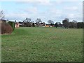
Green space in Westerhope
One of many pockets of green space within the City of Newcastle. This belt of open land separates the suburbs of Westerhope (to the left) and West Denton. The bungalows are on Roachburn Road.
Image: © Oliver Dixon
Taken: 1 Feb 2013
0.15 miles
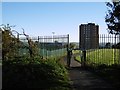
6
Path, Westerhope
A stripwood is shown here in 1898 maps. The open land to the south (left) is a school playing field.
Image: © Richard Webb
Taken: 1 Oct 2015
0.20 miles