IMAGES TAKEN NEAR TO
Rosemount, NEWCASTLE UPON TYNE, NE5 5JF
Introduction
This page details the photographs taken nearby to Rosemount, NE5 5JF by members of the Geograph project.
The Geograph project started in 2005 with the aim of publishing, organising and preserving representative images for every square kilometre of Great Britain, Ireland and the Isle of Man.

There are currently over 7.5m images from over14,400 individuals and you can help contribute to the project by visiting https://www.geograph.org.uk
Image Map (Loading...)


Getting Data...Please wait
Leaflet Map data © OpenStreetMap
Images are licensed for reuse under creativecommons.org/licenses/by-sa/2.0
Notes
- Clicking on the map will re-center to the selected point.
- The higher the marker number, the further away the image location is from the centre of the postcode.
Image Listing (14 Images Found)
Images are licensed for reuse under creativecommons.org/licenses/by-sa/2.0
Image
Details
Distance
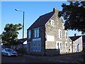
6
Former Co-op Building
The Co-op was built here in 1908 to serve the villagers, now in other use.
Image: © sue hayton
Taken: 11 Aug 2002
0.18 miles
8
Westerhope Village Nursery
The building was originally a Police Station
Image: © Anthony Foster
Taken: 27 Jul 2011
0.19 miles
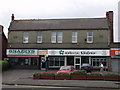
9
Willey and Co.
Accountants, Stamfordham Road.
Image: © Richard Webb
Taken: 1 Oct 2015
0.20 miles
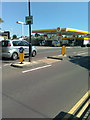
10
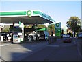
Garage, Stamfordham Road
October 2015: Petrol £1:10, Diesel £1.11 per litre.
Image: © Richard Webb
Taken: 1 Oct 2015
0.21 miles