IMAGES TAKEN NEAR TO
East Thorp, NEWCASTLE UPON TYNE, NE5 4JB
Introduction
This page details the photographs taken nearby to East Thorp, NE5 4JB by members of the Geograph project.
The Geograph project started in 2005 with the aim of publishing, organising and preserving representative images for every square kilometre of Great Britain, Ireland and the Isle of Man.

There are currently over 7.5m images from over14,400 individuals and you can help contribute to the project by visiting https://www.geograph.org.uk
Image Map (Loading...)


Getting Data...Please wait
Leaflet Map data © OpenStreetMap
Images are licensed for reuse under creativecommons.org/licenses/by-sa/2.0
Notes
- Clicking on the map will re-center to the selected point.
- The higher the marker number, the further away the image location is from the centre of the postcode.
Image Listing (18 Images Found)
Images are licensed for reuse under creativecommons.org/licenses/by-sa/2.0
Image
Details
Distance
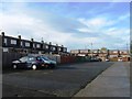
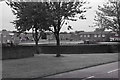
2
Newbiggin Hall
Hareydene and Bedeburn Road junction
Image: © peter maddison
Taken: 22 Sep 2010
0.06 miles
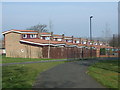
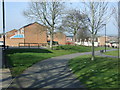
5
Newbiggin Hall, Hareydene
Houses in Newbiggin Hall, Hareydene
Image: © peter maddison
Taken: 22 Sep 2010
0.12 miles
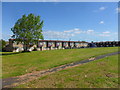

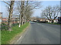
10
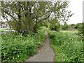
Hareydene
The tarmac surface suggests that this was a road predating the development of the Haredene housing estate to the left.
Image: © Oliver Dixon
Taken: 10 May 2023
0.18 miles