IMAGES TAKEN NEAR TO
Eastgarth, NEWCASTLE UPON TYNE, NE5 4EX
Introduction
This page details the photographs taken nearby to Eastgarth, NE5 4EX by members of the Geograph project.
The Geograph project started in 2005 with the aim of publishing, organising and preserving representative images for every square kilometre of Great Britain, Ireland and the Isle of Man.

There are currently over 7.5m images from over14,400 individuals and you can help contribute to the project by visiting https://www.geograph.org.uk
Image Map
Images are licensed for reuse under creativecommons.org/licenses/by-sa/2.0
Notes
- Clicking on the map will re-center to the selected point.
- The higher the marker number, the further away the image location is from the centre of the postcode.
Image Listing (27 Images Found)
Images are licensed for reuse under creativecommons.org/licenses/by-sa/2.0
Image
Details
Distance
1
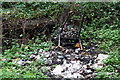
Trolley
The Burn shopping trolley in Bluebell Dene.
Image: © peter maddison
Taken: 11 Oct 2010
0.07 miles
2
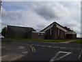
St Wilfred's Church Newbiggin Hall
St Wilfred's showing church hall and rear of the Church
Image: © Newbiggin Hall Scouts
Taken: 26 Mar 2007
0.09 miles
3
Wood
Bluebell Dene woodland in Newbiggin Hall, Newcastle Upon Tyne.
Image: © peter maddison
Taken: 11 Oct 2010
0.09 miles
4
Newbiggin Dene
Also known locally as Bluebell Wood and as Bluebell Dene.
Image: © Anthony Foster
Taken: 16 May 2021
0.09 miles
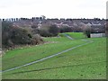
5
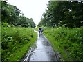
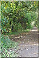
Walking in the rain
Part of a walk that is little used around Newbiggin Hall. In fact the council's own walking guide (part of a healthy heart campaign) even calls it the secret path. On the OS map it starts and stops but in fact is quite extensive.
Image: © Newbiggin Hall Scouts
Taken: 1 Jul 2007
0.10 miles
6
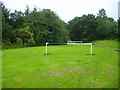
Goalposts
Goalposts on what is according to the OS map a stream, Maybe the water bred the posts there is a similar set just around the corner.
Image: © Newbiggin Hall Scouts
Taken: 1 Jul 2007
0.12 miles
7
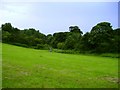
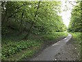
Secret path
Another part of the secret walk
Image: © Newbiggin Hall Scouts
Taken: 1 Jul 2007
0.16 miles
8
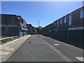
Newbiggin Hall Shopping Centre
This was once a busy shopping precinct but much of it has now closed and some units have been demolished.
Image: © Anthony Foster
Taken: 30 May 2020
0.16 miles
9
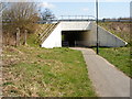
Subway under A696
Subway under the A696 from the Newbiggin Hall end leading to the path through Tudor Grange towards Bankfoot Metro. This picture is an update requested by Geograph for comments I made on an earlier picture of the same subway.
Image: © David Thornton
Taken: 16 Apr 2010
0.17 miles
10
Newbiggin Dene
A shallow valley and urban green space in the Newbiggin Hall Estate.
Image: © Oliver Dixon
Taken: 1 Feb 2013
0.17 miles