IMAGES TAKEN NEAR TO
Whitbeck Court, NEWCASTLE UPON TYNE, NE5 2XF
Introduction
This page details the photographs taken nearby to Whitbeck Court, NE5 2XF by members of the Geograph project.
The Geograph project started in 2005 with the aim of publishing, organising and preserving representative images for every square kilometre of Great Britain, Ireland and the Isle of Man.

There are currently over 7.5m images from over14,400 individuals and you can help contribute to the project by visiting https://www.geograph.org.uk
Image Map
Images are licensed for reuse under creativecommons.org/licenses/by-sa/2.0
Notes
- Clicking on the map will re-center to the selected point.
- The higher the marker number, the further away the image location is from the centre of the postcode.
Image Listing (39 Images Found)
Images are licensed for reuse under creativecommons.org/licenses/by-sa/2.0
Image
Details
Distance
1
Path on the former Montague Colliery
Image: © Anthony Foster
Taken: 24 Apr 2020
0.04 miles
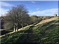
2

Path on the former Montague Colliery
Image: © Anthony Foster
Taken: 25 Jul 2020
0.05 miles

5
Path bifurcation on the former Montague Colliery
Image: © Anthony Foster
Taken: 25 Oct 2020
0.10 miles
6
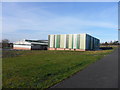
Tyneside Badminton Centre
Formerly the Slatyford Play and Youth Centre Image
Image: © Anthony Foster
Taken: 28 Feb 2014
0.11 miles
7

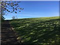
Greenspace on the former Montague Colliery
Image: © Anthony Foster
Taken: 24 Apr 2020
0.11 miles