IMAGES TAKEN NEAR TO
Loweswater Road, NEWCASTLE UPON TYNE, NE5 2SN
Introduction
This page details the photographs taken nearby to Loweswater Road, NE5 2SN by members of the Geograph project.
The Geograph project started in 2005 with the aim of publishing, organising and preserving representative images for every square kilometre of Great Britain, Ireland and the Isle of Man.

There are currently over 7.5m images from over14,400 individuals and you can help contribute to the project by visiting https://www.geograph.org.uk
Image Map (Loading...)


Getting Data...Please wait
Leaflet Map data © OpenStreetMap
Images are licensed for reuse under creativecommons.org/licenses/by-sa/2.0
Notes
- Clicking on the map will re-center to the selected point.
- The higher the marker number, the further away the image location is from the centre of the postcode.
Image Listing (26 Images Found)
Images are licensed for reuse under creativecommons.org/licenses/by-sa/2.0
Image
Details
Distance
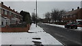
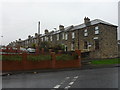
3

Upper Denton Dene
Denton Burn runs underneath in a culvert.
Image: © Anthony Foster
Taken: 18 Mar 2018
0.12 miles
4
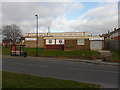
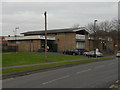
Montagu and North Fenham Boys' Club
Founded in 1948 'Monty' is one of Newcastle's oldest Boys' Clubs
Image: © Anthony Foster
Taken: 1 Mar 2013
0.14 miles
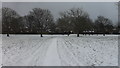
5
Caroline Cottages
A row of miners houses that served the former Montague Colliery nearby. See Image
Image: © Anthony Foster
Taken: 12 Apr 2015
0.15 miles
7
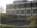
Gutted Building
Fire destroyed former headquarters of NEEB I think.
Image: © MSX
Taken: 29 Oct 2005
0.16 miles
10
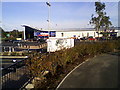
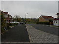
Retail park
New retail park on the site of derelict NEEB headquarters.
Image: © T simpson
Taken: 26 Aug 2007
0.17 miles