IMAGES TAKEN NEAR TO
Ovington Grove, NEWCASTLE UPON TYNE, NE5 2QH
Introduction
This page details the photographs taken nearby to Ovington Grove, NE5 2QH by members of the Geograph project.
The Geograph project started in 2005 with the aim of publishing, organising and preserving representative images for every square kilometre of Great Britain, Ireland and the Isle of Man.

There are currently over 7.5m images from over14,400 individuals and you can help contribute to the project by visiting https://www.geograph.org.uk
Image Map
Images are licensed for reuse under creativecommons.org/licenses/by-sa/2.0
Notes
- Clicking on the map will re-center to the selected point.
- The higher the marker number, the further away the image location is from the centre of the postcode.
Image Listing (20 Images Found)
Images are licensed for reuse under creativecommons.org/licenses/by-sa/2.0
Image
Details
Distance
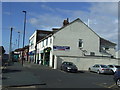
3
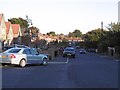
Cypress Avenue
The houses on the left are new.
Image: © Richard Webb
Taken: 1 Oct 2015
0.12 miles
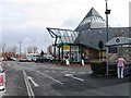
4
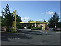
Supermarket service station
Off Two Ball Lonnen (B1305).
Image: © JThomas
Taken: 3 Aug 2013
0.13 miles
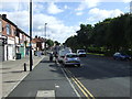
6
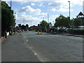
Two Ball Lonnen (B1305)
Approaching roundabout.
Image: © JThomas
Taken: 3 Aug 2013
0.16 miles
8
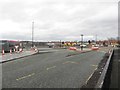
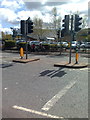
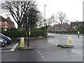
Road junction alterations, Cowgate, Newcastle upon Tyne
As part of major works to remove the roundabout at Cowgate junction the nearby junction of Two Ball Lonnen and Stamfordham Road (pictured here) has also undergone extensive remodelling in an attempt to improve the flow of traffic.
Image: © Graham Robson
Taken: 10 Jan 2016
0.18 miles
10
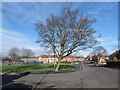
Green space in Fenham
One of many pockets of green space within the city of Newcastle. Queensway runs ahead, and Willow Avenue to the left. A corner of Willow Avenue Community Nursery can be seen to the left.
Image: © Oliver Dixon
Taken: 1 Feb 2013
0.20 miles