IMAGES TAKEN NEAR TO
Silver Lonnen, NEWCASTLE UPON TYNE, NE5 2JN
Introduction
This page details the photographs taken nearby to Silver Lonnen, NE5 2JN by members of the Geograph project.
The Geograph project started in 2005 with the aim of publishing, organising and preserving representative images for every square kilometre of Great Britain, Ireland and the Isle of Man.

There are currently over 7.5m images from over14,400 individuals and you can help contribute to the project by visiting https://www.geograph.org.uk
Image Map (Loading...)


Getting Data...Please wait
Leaflet Map data © OpenStreetMap
Images are licensed for reuse under creativecommons.org/licenses/by-sa/2.0
Notes
- Clicking on the map will re-center to the selected point.
- The higher the marker number, the further away the image location is from the centre of the postcode.
Image Listing (35 Images Found)
Images are licensed for reuse under creativecommons.org/licenses/by-sa/2.0
Image
Details
Distance
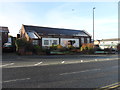
1
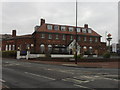
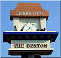
The Denton, Denton Burn
Landmark pub on Newcastle's West Road opened by Arrol's in June 1937 to serve new housing developments.
Source: Bennison Brian, Lost Weekends - A History of Newcastle's Public Houses: Volume Three The West, Newcastle Libraries and Information Service 1998
Image: © Anthony Foster
Taken: 1 Mar 2013
0.04 miles
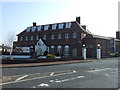
7

West Road
Benwell Hill going East into Newcastle.
Image: © MSX
Taken: 29 Oct 2005
0.09 miles
8
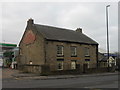
Solomons, Denton Burn
The building used to be the farmhouse of Thorntree Farm.
To the left is a very small section of Hadrian's Wall.
Image: © Anthony Foster
Taken: 1 Mar 2013
0.10 miles
9
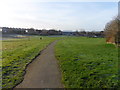
Denton Dene
Denton Burn flows through the Dene in a culvert
Image: © Anthony Foster
Taken: 28 Feb 2014
0.11 miles
10
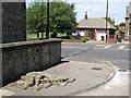
(A very small part of) Hadrian's Wall
This is the first section of Hadrian's Wall to be seen to the west of central Newcastle. It lies in the forecourt of a petrol station at the southwest of the roundabout at the junction of West Road and Denton Road.
Image: © Mike Quinn
Taken: 9 Jun 2008
0.11 miles