IMAGES TAKEN NEAR TO
Rosedale Court, NEWCASTLE UPON TYNE, NE5 2JH
Introduction
This page details the photographs taken nearby to Rosedale Court, NE5 2JH by members of the Geograph project.
The Geograph project started in 2005 with the aim of publishing, organising and preserving representative images for every square kilometre of Great Britain, Ireland and the Isle of Man.

There are currently over 7.5m images from over14,400 individuals and you can help contribute to the project by visiting https://www.geograph.org.uk
Image Map (Loading...)


Getting Data...Please wait
Leaflet Map data © OpenStreetMap
Images are licensed for reuse under creativecommons.org/licenses/by-sa/2.0
Notes
- Clicking on the map will re-center to the selected point.
- The higher the marker number, the further away the image location is from the centre of the postcode.
Image Listing (24 Images Found)
Images are licensed for reuse under creativecommons.org/licenses/by-sa/2.0
Image
Details
Distance
1
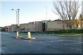
West Denton fire station
West Denton fire station, West Denton Way, West Denton, Tyne & Wear
Image: © Kevin Hale
Taken: 26 Nov 2006
0.07 miles
3
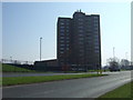
Tower block, West Denton
Off West Denton Way.
Image: © JThomas
Taken: 9 Apr 2015
0.13 miles
4
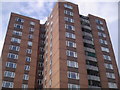
Denton Park Court
Tower Block adjacent to Shopping Centre
Image: © MSX
Taken: 29 Oct 2005
0.13 miles
5
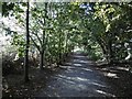
Path, Westerhope
A stripwood is shown here in 1898 maps. The open land to the south (left) is a school playing field.
Image: © Richard Webb
Taken: 1 Oct 2015
0.17 miles
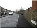
8
Hillhead Road near junction with West Denton Way
Image: © Andrew Curtis
Taken: 1 Dec 2013
0.19 miles
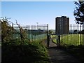
9
Covered reservoir, Westerhope
A flat man made surface is the highest point in the Newcastle Upon Tyne council area.
Image: © Richard Webb
Taken: 1 Oct 2015
0.19 miles
10

Outer West Library/Pool
All-in-one facility for residents of the "Outer West".
Image: © MSX
Taken: 29 Oct 2005
0.19 miles