IMAGES TAKEN NEAR TO
Allendale Court, NEWCASTLE UPON TYNE, NE5 2FD
Introduction
This page details the photographs taken nearby to Allendale Court, NE5 2FD by members of the Geograph project.
The Geograph project started in 2005 with the aim of publishing, organising and preserving representative images for every square kilometre of Great Britain, Ireland and the Isle of Man.

There are currently over 7.5m images from over14,400 individuals and you can help contribute to the project by visiting https://www.geograph.org.uk
Image Map
Images are licensed for reuse under creativecommons.org/licenses/by-sa/2.0
Notes
- Clicking on the map will re-center to the selected point.
- The higher the marker number, the further away the image location is from the centre of the postcode.
Image Listing (36 Images Found)
Images are licensed for reuse under creativecommons.org/licenses/by-sa/2.0
Image
Details
Distance
1

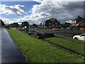
Green space in West Denton
One of many pockets of green space within the city of Newcastle; alongside Burwell Avenue.
Image: © Oliver Dixon
Taken: 1 Feb 2013
0.02 miles
2
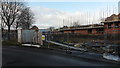
New Housing, Dunblane Crescent, West Denton
Image: © Anthony Foster
Taken: 1 Jan 2018
0.05 miles

5
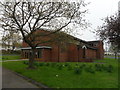
Church of the Holy Spirit, West Denton
Image: © Anthony Foster
Taken: 7 May 2016
0.13 miles

7
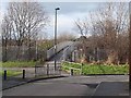
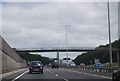
Footbridge over the A1
The A1, aka the Great North Road, is now routed through the western suburbs of Newcastle. This footbridge links the Drive in East Denton with Burwell Avenue in West Denton.
Image: © Oliver Dixon
Taken: 1 Feb 2013
0.16 miles