IMAGES TAKEN NEAR TO
Denham Walk, NEWCASTLE UPON TYNE, NE5 1JD
Introduction
This page details the photographs taken nearby to Denham Walk, NE5 1JD by members of the Geograph project.
The Geograph project started in 2005 with the aim of publishing, organising and preserving representative images for every square kilometre of Great Britain, Ireland and the Isle of Man.

There are currently over 7.5m images from over14,400 individuals and you can help contribute to the project by visiting https://www.geograph.org.uk
Image Map
Images are licensed for reuse under creativecommons.org/licenses/by-sa/2.0
Notes
- Clicking on the map will re-center to the selected point.
- The higher the marker number, the further away the image location is from the centre of the postcode.
Image Listing (5 Images Found)
Images are licensed for reuse under creativecommons.org/licenses/by-sa/2.0
Image
Details
Distance
1
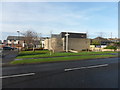
Church of the Holy Nativity, Chapel House Estate
Image: © Anthony Foster
Taken: 17 Dec 2016
0.21 miles
3
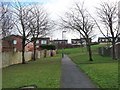
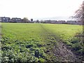
Walkway in Westerhope
This walkway, providing a route for walkers and cyclists away from the road, runs for about a kilometre along a narrow belt of green space through Westerhope. Kinver Drive and Kidderminster Drive to the right, Kiln Close to the left, Kenmoor Way ahead.
Image: © Oliver Dixon
Taken: 1 Feb 2013
0.23 miles