IMAGES TAKEN NEAR TO
Chadderton Drive, NEWCASTLE UPON TYNE, NE5 1HS
Introduction
This page details the photographs taken nearby to Chadderton Drive, NE5 1HS by members of the Geograph project.
The Geograph project started in 2005 with the aim of publishing, organising and preserving representative images for every square kilometre of Great Britain, Ireland and the Isle of Man.

There are currently over 7.5m images from over14,400 individuals and you can help contribute to the project by visiting https://www.geograph.org.uk
Image Map
Images are licensed for reuse under creativecommons.org/licenses/by-sa/2.0
Notes
- Clicking on the map will re-center to the selected point.
- The higher the marker number, the further away the image location is from the centre of the postcode.
Image Listing (15 Images Found)
Images are licensed for reuse under creativecommons.org/licenses/by-sa/2.0
Image
Details
Distance
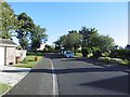
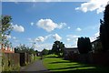
1
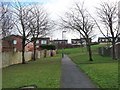
Walkway in Westerhope
This walkway, providing a route for walkers and cyclists away from the road, runs for about a kilometre along a narrow belt of green space through Westerhope. Kinver Drive and Kidderminster Drive to the right, Kiln Close to the left, Kenmoor Way ahead.
Image: © Oliver Dixon
Taken: 1 Feb 2013
0.09 miles
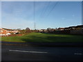
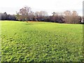
6
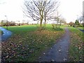
Open space, North Walbottle
This grassed area was formerly the site of Coronation Pit of Walbottle Colliery.
Image: © Andrew Curtis
Taken: 1 Dec 2013
0.19 miles
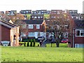
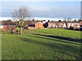
7
Northumberland Gardens, North Walbottle
Northumberland Gardens is a small planned estate of 31 mainly semi-detached houses lying between North Walbottle Road and North Walbottle Waggonway, on the western edge of Newcastle. It was designated a conservation area in 1987 because this small suburb of the City is unique to Newcastle and probably Tyneside as a whole in being an early 20th century creation contemporary with the Garden City Movement.
The Walbottle Workman's Association, like similar self-help agencies, wished to build adequate artisan houses with a generous allotment of land to provide a
measure of self sufficiency in fresh food. In 1910, the estate was laid out and built with mostly paired modest brick houses, large hedged gardens, intended to use as practical small holdings and linked by informal tree-lined private (unadopted) lanes with wide grass verges.
The site upon which the estate was constructed was open field until the housing was built. Immediately to the north and east, however, was the site of the Coronation Pit and the line of the North Walbottle Waggonway.
Image: © Andrew Curtis
Taken: 1 Dec 2013
0.20 miles
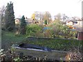
9
Open space, North Walbottle
Land reclaimed from the former Coronation Pit of Walbottle Colliery.
Image: © Andrew Curtis
Taken: 1 Dec 2013
0.20 miles
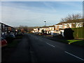
10
Bridleway through North Walbottle
The bridleway between Chapel Park and The Boltons housing estates is built on the line of the former North Walbottle waggonway
Image: © Anthony Foster
Taken: 29 Jul 2012
0.22 miles