IMAGES TAKEN NEAR TO
Lily Place, NE5 1ES
Introduction
This page details the photographs taken nearby to Lily Place, NE5 1ES by members of the Geograph project.
The Geograph project started in 2005 with the aim of publishing, organising and preserving representative images for every square kilometre of Great Britain, Ireland and the Isle of Man.

There are currently over 7.5m images from over14,400 individuals and you can help contribute to the project by visiting https://www.geograph.org.uk
Image Map (Loading...)


Getting Data...Please wait
Leaflet Map data © OpenStreetMap
Images are licensed for reuse under creativecommons.org/licenses/by-sa/2.0
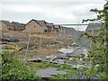
Notes
- Clicking on the map will re-center to the selected point.
- The higher the marker number, the further away the image location is from the centre of the postcode.
Image Listing (18 Images Found)
Images are licensed for reuse under creativecommons.org/licenses/by-sa/2.0
Image
Details
Distance
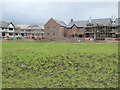
3
Hodgson Close
Part of the extensive new St John's Manor housing estate.
Image: © Oliver Dixon
Taken: 10 May 2023
0.14 miles
7
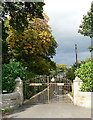
Whorlton Hall
At least the gates to it!
About six miles north-west of Newcastle upon Tyne
Image: © Chris Tweedy
Taken: 10 Oct 2005
0.18 miles

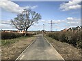
10
Callerton Rise
Houses nearing completion on the huge (500+) Callerton Rise development.
Image: © Oliver Dixon
Taken: 10 May 2023
0.22 miles