IMAGES TAKEN NEAR TO
Watson Road, NEWCASTLE UPON TYNE, NE5 1BU
Introduction
This page details the photographs taken nearby to Watson Road, NE5 1BU by members of the Geograph project.
The Geograph project started in 2005 with the aim of publishing, organising and preserving representative images for every square kilometre of Great Britain, Ireland and the Isle of Man.

There are currently over 7.5m images from over14,400 individuals and you can help contribute to the project by visiting https://www.geograph.org.uk
Image Map
Images are licensed for reuse under creativecommons.org/licenses/by-sa/2.0
Notes
- Clicking on the map will re-center to the selected point.
- The higher the marker number, the further away the image location is from the centre of the postcode.
Image Listing (27 Images Found)
Images are licensed for reuse under creativecommons.org/licenses/by-sa/2.0
Image
Details
Distance
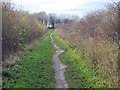
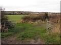
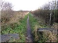
6
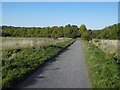
Track near Callerton
A useful shortcut between Stamfordham Road and North Walbottle Road.
Image: © Richard Webb
Taken: 1 Oct 2015
0.13 miles
7
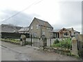
The Cottage on Whorlton Lane
Some cottage! The scattered dwellings along the very quiet Whorlton Lane are threatened by huge new housing developments to the west.
Image: © Oliver Dixon
Taken: 10 May 2023
0.19 miles