IMAGES TAKEN NEAR TO
Arkleside Place, NEWCASTLE UPON TYNE, NE5 1BA
Introduction
This page details the photographs taken nearby to Arkleside Place, NE5 1BA by members of the Geograph project.
The Geograph project started in 2005 with the aim of publishing, organising and preserving representative images for every square kilometre of Great Britain, Ireland and the Isle of Man.

There are currently over 7.5m images from over14,400 individuals and you can help contribute to the project by visiting https://www.geograph.org.uk
Image Map (Loading...)


Getting Data...Please wait
Leaflet Map data © OpenStreetMap
Images are licensed for reuse under creativecommons.org/licenses/by-sa/2.0
Notes
- Clicking on the map will re-center to the selected point.
- The higher the marker number, the further away the image location is from the centre of the postcode.
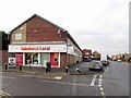
Image Listing (14 Images Found)
Images are licensed for reuse under creativecommons.org/licenses/by-sa/2.0
Image
Details
Distance
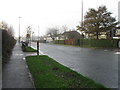
1
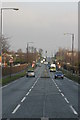
Hillhead Road, Chapel House Estate
Looking north.
Image: © Phil Thirkell
Taken: 9 Jan 2006
0.07 miles
6
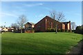
St John Vianney RC Church, West Denton
Image: © Anthony Foster
Taken: 17 Dec 2016
0.16 miles
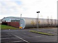
7
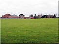
Playing Field near St John Vianney RC Church, Hillhead Parkway, West Denton
Image: © Andrew Curtis
Taken: 1 Dec 2013
0.16 miles
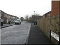
9
The Peregrine public house, Chapel House Estate
Image: © Phil Thirkell
Taken: 9 Jan 2006
0.20 miles
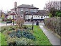
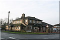
10
The Peregrine public house, Chapel House Estate
Image: © Phil Thirkell
Taken: 9 Jan 2006
0.20 miles