IMAGES TAKEN NEAR TO
HALTWHISTLE, NE49 9NP
Introduction
This page details the photographs taken nearby to NE49 9NP by members of the Geograph project.
The Geograph project started in 2005 with the aim of publishing, organising and preserving representative images for every square kilometre of Great Britain, Ireland and the Isle of Man.

There are currently over 7.5m images from over14,400 individuals and you can help contribute to the project by visiting https://www.geograph.org.uk
Image Map
Images are licensed for reuse under creativecommons.org/licenses/by-sa/2.0
Notes
- Clicking on the map will re-center to the selected point.
- The higher the marker number, the further away the image location is from the centre of the postcode.
Image Listing (20 Images Found)
Images are licensed for reuse under creativecommons.org/licenses/by-sa/2.0
Image
Details
Distance
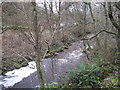
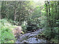
2
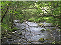
Haltwhistle Burn
Looking downstream from the footbridge near Broomshaw Hill Farm.
Image: © Mike Quinn
Taken: 18 Aug 2011
0.05 miles
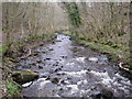
6
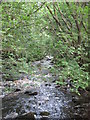
Haltwhistle Burn (2)
Looking upstream from the footbridge near Broomshaw Hill Farm.
Image: © Mike Quinn
Taken: 18 Aug 2011
0.09 miles
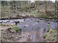
8
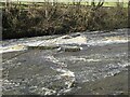
Haltwhistle Burn
This looks as if planks of wood have been fixed into the burn bed to divert the burn. Not certain why.
Image: © Les Hull
Taken: 22 Mar 2023
0.10 miles
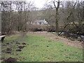
9
Haltwhistle Burn (3)
The eroded bank on the left has been strengthened with large blocks of stone.
Image: © Mike Quinn
Taken: 18 Aug 2011
0.11 miles