IMAGES TAKEN NEAR TO
The Mart, HALTWHISTLE, NE49 9HF
Introduction
This page details the photographs taken nearby to The Mart, NE49 9HF by members of the Geograph project.
The Geograph project started in 2005 with the aim of publishing, organising and preserving representative images for every square kilometre of Great Britain, Ireland and the Isle of Man.

There are currently over 7.5m images from over14,400 individuals and you can help contribute to the project by visiting https://www.geograph.org.uk
Image Map
Images are licensed for reuse under creativecommons.org/licenses/by-sa/2.0
Notes
- Clicking on the map will re-center to the selected point.
- The higher the marker number, the further away the image location is from the centre of the postcode.
Image Listing (311 Images Found)
Images are licensed for reuse under creativecommons.org/licenses/by-sa/2.0
Image
Details
Distance
2
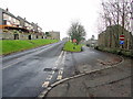
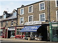
Haltwhistle Market Square
A market charter was first granted to Haltwhistle in 1306. There is still a range of independent shops; the prominent Clive Brown's sells D-I-Y, next door Billy Bell is a fishmonger.
Image: © Stephen McKay
Taken: 2 Oct 2007
0.06 miles
3
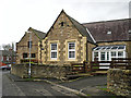
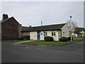
School converted to housing
View from Willia Road, the site extends round the corner to Fair Hill.
Image: © Rose and Trev Clough
Taken: 8 Nov 2014
0.06 miles
4

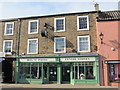
Army Surplus
These shops were fairly commonplace after the last war, with so much surplus equipment being available for disposal. Less so now, but this one in Haltwhistle appears to be thriving with the aid of a healthy online presence.
The reference to the 'Centre of Britain' is interesting. Tradition has it that Haltwhistle has that honour, but Ordnance Survey have it as the Whitendale Hanging Stones, near Brennand Farm, outside Dunsop Bridge, Lancashire in the Forest of Bowland. (Image). Haltwhistle is a 'centre' by another calculation, it being the midpoint of the longest north–south meridian; also approximately the midpoint of each of the lines through it across Great Britain along the 16 main compass directions.
Image: © John Lucas
Taken: 6 Oct 2021
0.07 miles
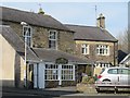
6
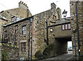
The back of a converted bastle house
Bastles were fortified houses with very thick walls, built to withstand attack by the Border Reivers http://en.wikipedia.org/wiki/Border_Reivers . When troubled times passed the houses were made more comfortable, e.g. by replacing a ladder to the upper floor with steps (though in this house the steps currently lead nowhere).
The front of the building is seen here Image
Image: © Rose and Trev Clough
Taken: 8 Nov 2014
0.07 miles

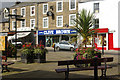
10
Shops, Market Place
Shows the location of Image
Image: © Mike Quinn
Taken: 28 Mar 2012
0.07 miles