IMAGES TAKEN NEAR TO
Douglas Smith Bungalows, HALTWHISTLE, NE49 9BJ
Introduction
This page details the photographs taken nearby to Douglas Smith Bungalows, NE49 9BJ by members of the Geograph project.
The Geograph project started in 2005 with the aim of publishing, organising and preserving representative images for every square kilometre of Great Britain, Ireland and the Isle of Man.

There are currently over 7.5m images from over14,400 individuals and you can help contribute to the project by visiting https://www.geograph.org.uk
Image Map
Images are licensed for reuse under creativecommons.org/licenses/by-sa/2.0
Notes
- Clicking on the map will re-center to the selected point.
- The higher the marker number, the further away the image location is from the centre of the postcode.
Image Listing (31 Images Found)
Images are licensed for reuse under creativecommons.org/licenses/by-sa/2.0
Image
Details
Distance
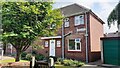
1
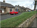
Douglas Smith Bungalows, Park Road, Haltwhistle
Was Douglas Smith a benefactor?
Image: © Christine Johnstone
Taken: 17 Feb 2020
0.01 miles
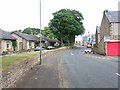
2
Traffic calming, Park Road, Haltwhistle
Heading west out of town.
Image: © Christine Johnstone
Taken: 17 Feb 2020
0.02 miles
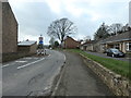
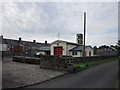
3
Park Road, Haltwhistle
Sheltered housing on the left
Image: © Oliver Dixon
Taken: 20 Jul 2006
0.03 miles
4
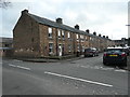
The east side of Lorne Street, Haltwhistle
On the south side of Park Road.
Image: © Christine Johnstone
Taken: 17 Feb 2020
0.03 miles
5
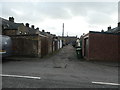
Back lane between Lorne Street and Dale Street
On the south side of Park Road, Haltwhistle.
Image: © Christine Johnstone
Taken: 17 Feb 2020
0.04 miles
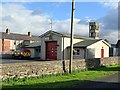
6

Haltwhistle fire station
Haltwhistle fire station, Park Road, Haltwhistle, Northumberland
Image: © Kevin Hale
Taken: 2 Aug 2010
0.05 miles
9
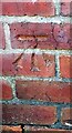
Benchmark on #4 Park Road
Park Road according to Ordnance Survey records, but I think it may be Westlands. Ordnance Survey cut mark benchmark levelled at 127.093m above Newlyn Datum verified 1954
Image: © Roger Templeman
Taken: 26 May 2023
0.07 miles
10
#4 Park Road (Westlands?)
There is an Ordnance Survey benchmark Image on the near corner, left hand face, of the house
Image: © Roger Templeman
Taken: 26 May 2023
0.08 miles