IMAGES TAKEN NEAR TO
Coanwood, HALTWHISTLE, NE49 0QN
Introduction
This page details the photographs taken nearby to NE49 0QN by members of the Geograph project.
The Geograph project started in 2005 with the aim of publishing, organising and preserving representative images for every square kilometre of Great Britain, Ireland and the Isle of Man.

There are currently over 7.5m images from over14,400 individuals and you can help contribute to the project by visiting https://www.geograph.org.uk
Image Map
Images are licensed for reuse under creativecommons.org/licenses/by-sa/2.0
Notes
- Clicking on the map will re-center to the selected point.
- The higher the marker number, the further away the image location is from the centre of the postcode.
Image Listing (8 Images Found)
Images are licensed for reuse under creativecommons.org/licenses/by-sa/2.0
Image
Details
Distance
3
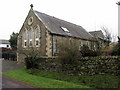
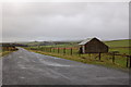
Former Methodist Chapel, New Stonehouse
Carved stone below the end gable windows, adjacent to the road, give a date of 1883.
Image: © Andrew Curtis
Taken: 13 Feb 2015
0.14 miles
7
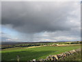
Storm approaching East and West stonehouse.
Taken on an evening walk.
Image: © steven ruffles
Taken: 23 Aug 2014
0.24 miles
8
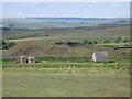
Disused colliery north of Dykes (2)
Photo taken from the minor road near Dykes in Image
Image: © Mike Quinn
Taken: 21 Jun 2010
0.25 miles