IMAGES TAKEN NEAR TO
Coanwood, HALTWHISTLE, NE49 0QJ
Introduction
This page details the photographs taken nearby to NE49 0QJ by members of the Geograph project.
The Geograph project started in 2005 with the aim of publishing, organising and preserving representative images for every square kilometre of Great Britain, Ireland and the Isle of Man.

There are currently over 7.5m images from over14,400 individuals and you can help contribute to the project by visiting https://www.geograph.org.uk
Image Map
Images are licensed for reuse under creativecommons.org/licenses/by-sa/2.0
Notes
- Clicking on the map will re-center to the selected point.
- The higher the marker number, the further away the image location is from the centre of the postcode.
Image Listing (8 Images Found)
Images are licensed for reuse under creativecommons.org/licenses/by-sa/2.0
Image
Details
Distance

2
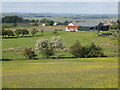
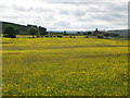
Farmland south of Moss House
Photo taken looking north from the minor road to the south of Moss House in Image
Image: © Mike Quinn
Taken: 21 Jun 2010
0.03 miles
3
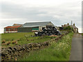
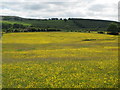
Moss House
Picture taken from midway between the two public footpaths to the south of the farm.
Image: © Andrew Smith
Taken: 4 Jun 2006
0.06 miles
5
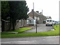
Lanehead
A small hamlet at the crossroads above Coanwood.
Image: © Oliver Dixon
Taken: 15 Jul 2008
0.13 miles
8
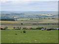
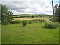
Pastures west of Dykehead and Birch Trees (3)
Just above the trees on the first horizon (right) is the lake shown in Image
Image: © Mike Quinn
Taken: 21 Jun 2010
0.25 miles