IMAGES TAKEN NEAR TO
HALTWHISTLE, NE49 0HJ
Introduction
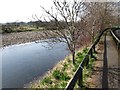
This page details the photographs taken nearby to NE49 0HJ by members of the Geograph project.
The Geograph project started in 2005 with the aim of publishing, organising and preserving representative images for every square kilometre of Great Britain, Ireland and the Isle of Man.

There are currently over 7.5m images from over14,400 individuals and you can help contribute to the project by visiting https://www.geograph.org.uk
Image Map
Images are licensed for reuse under creativecommons.org/licenses/by-sa/2.0
Notes
- Clicking on the map will re-center to the selected point.
- The higher the marker number, the further away the image location is from the centre of the postcode.
Image Listing (399 Images Found)
Images are licensed for reuse under creativecommons.org/licenses/by-sa/2.0
Image
Details
Distance
1
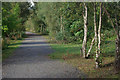
Old Railway, Haltwhistle
The former Alston branch line, just before it joined the main line at Haltwhistle station, has now been converted into a footpath lined with birch trees.
Image: © Stephen McKay
Taken: 2 Oct 2007
0.01 miles
2
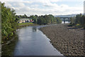
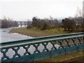
River South Tyne, Haltwhistle
The building on the left is the Albion Works which produces de-icing fluids. The viaduct formerly carried the Haltwhistle - Alston railway, closed in 1976.
Image: © Stephen McKay
Taken: 2 Oct 2007
0.03 miles
3

Collapsed and abandoned riverbank path, Haltwhistle
On the north bank of the River South Tyne. The Kilfrost factory alongside has given up a strip of its car park to create a new wider path.
Image: © Christine Johnstone
Taken: 17 Feb 2020
0.03 miles
4
River South Tyne from Haltwhistle Tyne Bridge
The Alston Arches railway viaduct is in the distance.
Image: © Andrew Curtis
Taken: 13 Feb 2015
0.04 miles
5
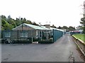
Kilfrost factory, Haltwhistle
The industrial under-belly of Haltwhistle, sandwiched between the railway and the river. Kilfrost manufacture de-icing products and materials for the aviation industry. To the right of the railings, a public bridleway continues along the river bank.
Image: © Oliver Dixon
Taken: 26 Sep 2010
0.05 miles
6
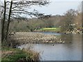
The River South Tyne between Alston Arches Viaduct and Tyne Bridge (2)
Image: © Mike Quinn
Taken: 29 Mar 2012
0.05 miles
7
![Alston Arches Trail [2], Haltwhistle](https://s0.geograph.org.uk/geophotos/06/39/37/6393748_4dd6717f_120x120.jpg)
Alston Arches Trail [2], Haltwhistle
The former branch line to Alston. Opened in 1851-52, closed in 1976. Re-opened in 2006 as part of a short circular walk and a link to the South Tyne Trail.
Image: © Christine Johnstone
Taken: 17 Feb 2020
0.05 miles
8
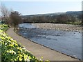
The River South Tyne downstream of Tyne Bridge (2)
Image: © Mike Quinn
Taken: 29 Mar 2012
0.05 miles