IMAGES TAKEN NEAR TO
HALTWHISTLE, NE49 0ES
Introduction
This page details the photographs taken nearby to NE49 0ES by members of the Geograph project.
The Geograph project started in 2005 with the aim of publishing, organising and preserving representative images for every square kilometre of Great Britain, Ireland and the Isle of Man.

There are currently over 7.5m images from over14,400 individuals and you can help contribute to the project by visiting https://www.geograph.org.uk
Image Map
Images are licensed for reuse under creativecommons.org/licenses/by-sa/2.0
Notes
- Clicking on the map will re-center to the selected point.
- The higher the marker number, the further away the image location is from the centre of the postcode.
Image Listing (117 Images Found)
Images are licensed for reuse under creativecommons.org/licenses/by-sa/2.0
Image
Details
Distance
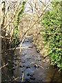
2
Haltwhistle Burn at Townfoot (2)
Looking downstream.
Image: © Mike Quinn
Taken: 26 Aug 2010
0.02 miles
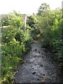
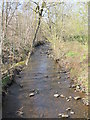
5
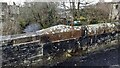
Haltwhistle Burn viewed over parapet of Townfoot Bridge
There is an Ordnance Survey benchmark Image on the parapet pier.
Image: © Roger Templeman
Taken: 14 Apr 2023
0.04 miles
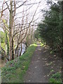
9
Haltwhistle Burn north of Avenue St. Meen (B6322)
Image: © Mike Quinn
Taken: 28 Mar 2012
0.05 miles