IMAGES TAKEN NEAR TO
Wydon Lane, HALTWHISTLE, NE49 0AN
Introduction
This page details the photographs taken nearby to Wydon Lane, NE49 0AN by members of the Geograph project.
The Geograph project started in 2005 with the aim of publishing, organising and preserving representative images for every square kilometre of Great Britain, Ireland and the Isle of Man.

There are currently over 7.5m images from over14,400 individuals and you can help contribute to the project by visiting https://www.geograph.org.uk
Image Map
Images are licensed for reuse under creativecommons.org/licenses/by-sa/2.0
Notes
- Clicking on the map will re-center to the selected point.
- The higher the marker number, the further away the image location is from the centre of the postcode.
Image Listing (36 Images Found)
Images are licensed for reuse under creativecommons.org/licenses/by-sa/2.0
Image
Details
Distance
1
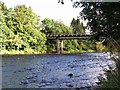
Bellister Bridge
Bellister Bridge was a temporary bridge built in 1967 to replace the Tyne Bridge near the station (which was no longer in use for vehicles) to give access to a plastics factory and to Plenmeller. It has now been made unnecessary since the opening of the Haltwhistle By-pass and serves as a footbridge from a residential area to the old road on the south side of the Tyne, from where the other pedestrian bridge, the Blue bridge, can be reached. It carried traffic until 1997 when the by-pass was opened.
http://www.bridgesonthetyne.co.uk/haltbell.html
Image: © Andrew Curtis
Taken: 25 Sep 2015
0.05 miles
2
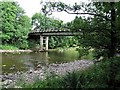
Haltwhistle Bellister Bridge
This was a temporary bridge built in 1967 to replace the Haltwhistle Tyne Bridge near the station (which was no longer in use for vehicles) to give access to a plastics factory and to Plenmeller. It has now been made unnecessary since the opening of the Haltwhistle By-pass and serves as a footbridge from a residential area to the old road on the south side of the Tyne, from where the other pedestrian bridge, the Blue Bridge, can be reached. It carried traffic until 1997 when the by-pass was opened. It is a beam bridge standing on concrete piers with a concrete deck carried on steel girders.
http://www.bridgesonthetyne.co.uk/haltbell.html
Image: © Andrew Curtis
Taken: 11 Jul 2018
0.06 miles
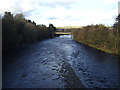
4
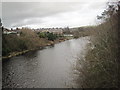
The River South Tyne (2)
Looking downstream from just below the A69 bridge.
Image: © Mike Quinn
Taken: 14 Sep 2010
0.08 miles
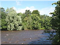
6
Small pasture next to the A69 and the River South Tyne
Image: © Mike Quinn
Taken: 14 Sep 2010
0.10 miles
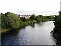
8
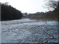
The River South Tyne upstream of Tyne Bridge
Image: © Mike Quinn
Taken: 29 Mar 2012
0.11 miles