
IMAGES TAKEN NEAR TO
Boat Road, HEXHAM, NE48 2AP
Introduction
This page details the photographs taken nearby to Boat Road, NE48 2AP by members of the Geograph project.
The Geograph project started in 2005 with the aim of publishing, organising and preserving representative images for every square kilometre of Great Britain, Ireland and the Isle of Man.

There are currently over 7.5m images from over14,400 individuals and you can help contribute to the project by visiting https://www.geograph.org.uk
Image Map
Images are licensed for reuse under creativecommons.org/licenses/by-sa/2.0
Notes
- Clicking on the map will re-center to the selected point.
- The higher the marker number, the further away the image location is from the centre of the postcode.
Image Listing (33 Images Found)
Images are licensed for reuse under creativecommons.org/licenses/by-sa/2.0
Image
Details
Distance
1

Mill Haughs
The north-east word haugh refers to a low-lying meadow in a river valley.
Image: © Andrew Curtis
Taken: 21 May 2025
0.12 miles


4

Hareshaw Burn just above its confluence with the River North Tyne
Image: © Mike Quinn
Taken: 16 Aug 2012
0.18 miles
5

The Confluence of the Hareshaw Burn and the River North Tyne
Image: © Les Hull
Taken: 20 Jan 2010
0.19 miles
6

Hareshaw Burn northeast of Boat Road, Bellingham, NE48
Image: © Mike Quinn
Taken: 16 Aug 2012
0.20 miles


9

Brookside Place, Bellingham
Up the hill to Manchester Square.
Image: © Barbara Carr
Taken: 27 Jul 2010
0.21 miles
10
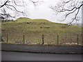
Motte of Bellingham Castle
A mound at the east end of Bellingham is all that remains of the former motte and bailey castle. It was probably built in the 12th century by the Bellingham family and is likely to have been replaced by a stone castle in the 13th century. The existence of a castle here is suggested by documentary evidence which reports that William de Bellingham, sheriff of Tynedale and forester of Tynedale under the king of Scotland, had his seat at Bellingham. The mound is topped by a smaller mound and, because the top of this feature is quite small, doubt has been expressed about the form of the castle if it was situated here; it has also been suggested that the whole mound is a natural feature.
http://www.keystothepast.info/durhamcc/K2P.nsf/K2PDetail?readform&PRN=N7979
Image: © Les Hull
Taken: 20 Jan 2010
0.21 miles