
IMAGES TAKEN NEAR TO
Park Road, NEWCASTLE UPON TYNE, NE4 7EP
Introduction
This page details the photographs taken nearby to Park Road, NE4 7EP by members of the Geograph project.
The Geograph project started in 2005 with the aim of publishing, organising and preserving representative images for every square kilometre of Great Britain, Ireland and the Isle of Man.

There are currently over 7.5m images from over14,400 individuals and you can help contribute to the project by visiting https://www.geograph.org.uk
Image Map
Images are licensed for reuse under creativecommons.org/licenses/by-sa/2.0
Notes
- Clicking on the map will re-center to the selected point.
- The higher the marker number, the further away the image location is from the centre of the postcode.
Image Listing (60 Images Found)
Images are licensed for reuse under creativecommons.org/licenses/by-sa/2.0
Image
Details
Distance
1
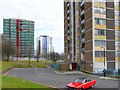
Cruddas Park
The Cruddas Park flats are at last being renovated. It was either that or total demolition which was also on the agenda for a while. Wimpey's original 1960's style (a Swedish modular system) can be seen on the nearby block. The block in the distance, 'The Sycamores', is more or less finished (at least externally), while the block on the left, 'The Hawthorns', is being worked on now.
Image: © Andrew Curtis
Taken: 11 Mar 2010
0.02 miles
2
North West to Newcastle
This image looks North-West towards Newcastle from the Angel of the North. It shows the tower blocks in Elswick and the TV transmitter at Fenham on the far horizon. To the left of the picture is Derwent Tower (the "Dunston Rocket")
Image: © Kevin Hall
Taken: 11 Sep 2011
0.03 miles
3
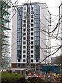
'The Sycamores', Cruddas Park
After face-lift 2010.
Image: © Andrew Curtis
Taken: 11 Mar 2010
0.03 miles
4
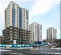
The refurbishment of the Cruddas Park tower blocks, Scotswood Road
From the left, the blocks along Park Road are named: The Pines, The Sycamores and The Larches.
Image: © Andrew Curtis
Taken: 26 Nov 2010
0.03 miles
5

Cruddas Park from Scotswood Road
Mix of low and high rise housing to the west of Newcastle's city centre; taken on a misty Sunday morning in 1974.
Image: © Colin Smith
Taken: Unknown
0.04 miles
6
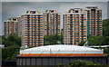
Cruddas Park
The flats at Cruddas Park seen from Bensham.
Image: © Peter McDermott
Taken: 7 Jun 2009
0.05 miles
7
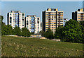
Elswick
The new and the old: renovation of flats in Elswick.
Image: © Peter McDermott
Taken: 1 May 2011
0.05 miles
8
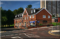
The Rock
The Rock public house in Elswick. For an earlier photograph by Andrew Curtis see Image
Image: © Peter McDermott
Taken: 2 Sep 2012
0.05 miles
9
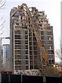
Demolition of The Poplars, Cruddas Park
Photo from 2010 Image
Image: © Andrew Curtis
Taken: 23 Mar 2012
0.06 miles
10
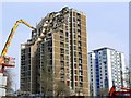
Last days of The Poplars, Cruddas Park
The Hawthorns, recently refurbished (and now part of Riverside Dene) is to the right.
Technical Demolition Services were awarded the Cruddas Park Tower Blocks Demolition Contract. Their web site http://www.technicaldemolitionservices.com/newspage.html#cruddas provides the following information:
The Cruddas Park housing scheme was part of T. Dan Smith's grand plan for a 'city in the sky'. Smith was from a working-class family in Wallsend rising to become a visionary leader of Newcastle City Council. He wanted to make Newcastle a modern city. His vision included urban motorways, a metro public transport system and high profile architecture (all of which Newcastle now enjoys). Work started on these tower blocks in 1961. Half a century later and the 2011 community’s housing requirements have changed. Technical Demolition Services are proud to be involved in demolishing the five tower blocks, regenerating the area, offering and enabling new visions of vibrancy for the future of Cruddas Park and community.
Image: © Andrew Curtis
Taken: 23 Mar 2012
0.06 miles