IMAGES TAKEN NEAR TO
Sparty Lea, HEXHAM, NE47 9UN
Introduction
This page details the photographs taken nearby to NE47 9UN by members of the Geograph project.
The Geograph project started in 2005 with the aim of publishing, organising and preserving representative images for every square kilometre of Great Britain, Ireland and the Isle of Man.

There are currently over 7.5m images from over14,400 individuals and you can help contribute to the project by visiting https://www.geograph.org.uk
Image Map
Images are licensed for reuse under creativecommons.org/licenses/by-sa/2.0
Notes
- Clicking on the map will re-center to the selected point.
- The higher the marker number, the further away the image location is from the centre of the postcode.
Image Listing (105 Images Found)
Images are licensed for reuse under creativecommons.org/licenses/by-sa/2.0
Image
Details
Distance
1
Old Dyke & St Peters across River East Allen
Image: © Andrew Curtis
Taken: 6 Oct 2020
0.01 miles
2
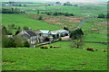
Rough pastures west of the old Corn Mill
Image: © Mike Quinn
Taken: 18 Apr 2014
0.02 miles

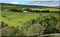
5

Spartylea (2)
Photo taken from near Image looking across the valley of the River East Allen and up the Swinhope Valley.
Image: © Mike Quinn
Taken: 23 Sep 2009
0.09 miles
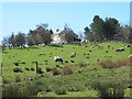
7
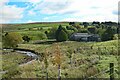
Corn Mill
View of Corn Mill farm seen from the B6295.
Image: © Peter McDermott
Taken: 10 May 2008
0.13 miles
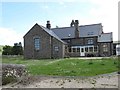
8
Farm buildings at Corn Mill by River East Allen
Image: © Andrew Curtis
Taken: 6 Oct 2020
0.14 miles
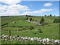
10
Track to the Corn Mill
The group of buildings at the Corn Mill is shown in Image (photo by Peter McDermott).
Image: © Mike Quinn
Taken: 2 Mar 2010
0.14 miles