IMAGES TAKEN NEAR TO
Fell View, HEXHAM, NE47 9UJ
Introduction
This page details the photographs taken nearby to Fell View, NE47 9UJ by members of the Geograph project.
The Geograph project started in 2005 with the aim of publishing, organising and preserving representative images for every square kilometre of Great Britain, Ireland and the Isle of Man.

There are currently over 7.5m images from over14,400 individuals and you can help contribute to the project by visiting https://www.geograph.org.uk
Image Map
Images are licensed for reuse under creativecommons.org/licenses/by-sa/2.0
Notes
- Clicking on the map will re-center to the selected point.
- The higher the marker number, the further away the image location is from the centre of the postcode.
Image Listing (68 Images Found)
Images are licensed for reuse under creativecommons.org/licenses/by-sa/2.0
Image
Details
Distance
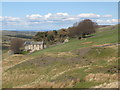
1
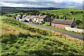
Fell View
A small hamlet previously called Coalpits.
Image: © Andrew Curtis
Taken: 6 Oct 2020
0.01 miles
3
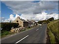
Fell View
Hamlet on the B6295 main road up East Allendale, looking north.
Image: © Oliver Dixon
Taken: 30 Sep 2010
0.02 miles
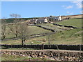
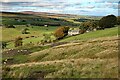
4
Fell View cottages
View from the path up to Green Hill. The track to Coatenhill Farm in Image can be seen in the top right hand corner, and Low Huntwell in Image on the far side of the East Allen is above the leftmost cottage.
Image: © Mike Quinn
Taken: 23 May 2007
0.03 miles
5
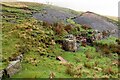
Disused quarry south of Ellershope Bridge
Image: © Mike Quinn
Taken: 12 Apr 2009
0.06 miles
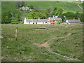
6
Old quarry near Elia House
The quarries above the road are shown as Byerhopebank Quarries on the 1st edition OS map. The name of Coalpit Sike and Coalpits and of the Brackenhill Shaft (part of the Blackett Level) indicate the extent of mining of both coal and lead in this area.
Image: © Andrew Curtis
Taken: 6 Oct 2020
0.06 miles
7
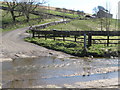
Try your brakes
The ford on the River East Allen near Low Huntwell, looking up towards the B6295 Allendale to Allenheads road.
Image: © Mike Quinn
Taken: 12 Apr 2009
0.07 miles
8
Perforated ground with somnolent sheep
The exposed earth has been heavily tunnelled by rabbits but its appearance and that of other ground nearby suggests historic human mining activity too. Elia House is just beyond.
Image: © Trevor Littlewood
Taken: 24 Jul 2020
0.07 miles
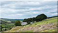
9
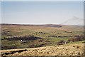
East Allen Dale (2)
Photo taken from below Byerhope Bank, looking across the valley past Coatenhill reservoir (left) towards Black Hill on the horiozon in Image
Image: © Mike Quinn
Taken: 19 Apr 2007
0.07 miles
10
Old quarry near Coalpit Sike
The northernmost of the disused Byerhopebank Quarries Image
Image: © Andrew Curtis
Taken: 13 Oct 2020
0.08 miles