IMAGES TAKEN NEAR TO
Sparty Lea, HEXHAM, NE47 9UH
Introduction
This page details the photographs taken nearby to NE47 9UH by members of the Geograph project.
The Geograph project started in 2005 with the aim of publishing, organising and preserving representative images for every square kilometre of Great Britain, Ireland and the Isle of Man.

There are currently over 7.5m images from over14,400 individuals and you can help contribute to the project by visiting https://www.geograph.org.uk
Image Map
Images are licensed for reuse under creativecommons.org/licenses/by-sa/2.0
Notes
- Clicking on the map will re-center to the selected point.
- The higher the marker number, the further away the image location is from the centre of the postcode.
Image Listing (80 Images Found)
Images are licensed for reuse under creativecommons.org/licenses/by-sa/2.0
Image
Details
Distance
1
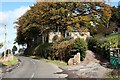
Elia House
Once house of the Colliery Manager and residence of doctors to the local mining community.
Image: © Andrew Curtis
Taken: 6 Oct 2020
0.07 miles
2
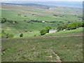
Elia House
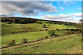
Looking northwest across the valley of the East Allen towards Black Hill in Image
Image: © Mike Quinn
Taken: 23 May 2007
0.07 miles
3
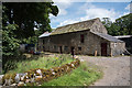
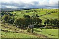
Large barn at Huntwell
The barn is north-east of the farmhouse at Low Huntwell and is presumably part of the farm; it's also close to the River East Allen which flows just beyond the buildings.
Image: © Trevor Littlewood
Taken: 24 Jul 2020
0.09 miles
6
Former Telephone Exchange near White Hill
Image: © Andrew Curtis
Taken: 6 Oct 2020
0.12 miles
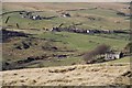
7
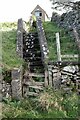
Ruin on the bank of the River East Allen near Low Huntwell
Image: © Mike Quinn
Taken: 26 May 2007
0.13 miles
10

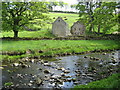
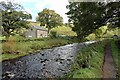
The River East Allen near Coatenhill (2)
Image: © Mike Quinn
Taken: 27 Sep 2008
0.13 miles