IMAGES TAKEN NEAR TO
/Low Shield Close, HEXHAM, NE47 9UD
Introduction
This page details the photographs taken nearby to /Low Shield Close, NE47 9UD by members of the Geograph project.
The Geograph project started in 2005 with the aim of publishing, organising and preserving representative images for every square kilometre of Great Britain, Ireland and the Isle of Man.

There are currently over 7.5m images from over14,400 individuals and you can help contribute to the project by visiting https://www.geograph.org.uk
Image Map
Images are licensed for reuse under creativecommons.org/licenses/by-sa/2.0
Notes
- Clicking on the map will re-center to the selected point.
- The higher the marker number, the further away the image location is from the centre of the postcode.
Image Listing (98 Images Found)
Images are licensed for reuse under creativecommons.org/licenses/by-sa/2.0
Image
Details
Distance
1
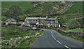
Lowshield Close, Ellershope Bridge, Spartylea
View of 'Spartylea Corner' c.1910 on Allen Valleys Local History Group website: http://www.allenvalleyslocalhistory.org.uk/photo/spartylea-1910-0033-003/ https://web.archive.org/web/20220918172320/http://www.allenvalleyslocalhistory.org.uk/photo/spartylea-1910-0033-003/
Image: © Andrew Curtis
Taken: 15 Sep 2022
0.01 miles
2
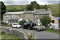
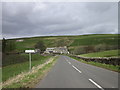
Spartylea
The B6295 at Spartylea in the valley of the river East Allen.
Image: © Peter McDermott
Taken: 10 May 2008
0.01 miles
6
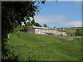
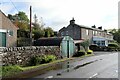
Row of cottages at Ellershope Bridge
The B6295 passes these cottages at the bridge over the Ellershope Burn; the view is from the west.
Image: © Trevor Littlewood
Taken: 24 Jun 2009
0.04 miles
9
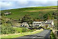
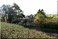
(The site of) St. Peter's Mine, Spartylea (2)
Photos of the mine in c.1900 and 1930 can be found in Jennifer W Norderhaug's book "Sparty Lea - An Upland Leadmining Community" (Wagtail Press, 2008).
Image: © Mike Quinn
Taken: 23 Sep 2009
0.08 miles
10
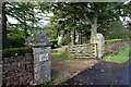
(The site of) St. Peter's Mine, Spartylea (4)
Image: © Mike Quinn
Taken: 23 Sep 2009
0.09 miles