IMAGES TAKEN NEAR TO
Sinderhope, HEXHAM, NE47 9SN
Introduction
This page details the photographs taken nearby to NE47 9SN by members of the Geograph project.
The Geograph project started in 2005 with the aim of publishing, organising and preserving representative images for every square kilometre of Great Britain, Ireland and the Isle of Man.

There are currently over 7.5m images from over14,400 individuals and you can help contribute to the project by visiting https://www.geograph.org.uk
Image Map
Images are licensed for reuse under creativecommons.org/licenses/by-sa/2.0
Notes
- Clicking on the map will re-center to the selected point.
- The higher the marker number, the further away the image location is from the centre of the postcode.
Image Listing (62 Images Found)
Images are licensed for reuse under creativecommons.org/licenses/by-sa/2.0
Image
Details
Distance
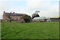
5
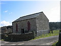
Barn near Pry Hill Farm
Impressive barn with ornate "church/chapel" type windows.
Image: © Les Hull
Taken: 18 Apr 2006
0.06 miles
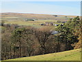
8
The valley of the River East Allen around Mill Haugh
Image: © Mike Quinn
Taken: 16 Apr 2014
0.08 miles
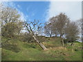
9
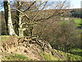
Exposed tree roots
Next to the path down to the River East Allen.
Image: © Mike Quinn
Taken: 31 Oct 2009
0.10 miles
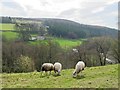
10
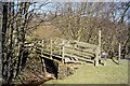
Footbridge over Knockshield burn
The bridge crosses the burn just before it enters the East Allen.
Image: © Mike Quinn
Taken: 5 Apr 2007
0.10 miles