IMAGES TAKEN NEAR TO
Sinderhope, HEXHAM, NE47 9SL
Introduction
This page details the photographs taken nearby to NE47 9SL by members of the Geograph project.
The Geograph project started in 2005 with the aim of publishing, organising and preserving representative images for every square kilometre of Great Britain, Ireland and the Isle of Man.

There are currently over 7.5m images from over14,400 individuals and you can help contribute to the project by visiting https://www.geograph.org.uk
Image Map
Images are licensed for reuse under creativecommons.org/licenses/by-sa/2.0
Notes
- Clicking on the map will re-center to the selected point.
- The higher the marker number, the further away the image location is from the centre of the postcode.
Image Listing (72 Images Found)
Images are licensed for reuse under creativecommons.org/licenses/by-sa/2.0
Image
Details
Distance
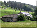
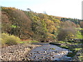
3
River East Allen at Mill Haugh
Blackbanks is the property further up the hill.
Image: © Andrew Curtis
Taken: 22 Sep 2020
0.03 miles
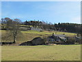
4
Old mill
Situated on a bend in the East Allen; traces of the water course for the mill can still be seen.
Image: © Mike Quinn
Taken: 5 Apr 2007
0.04 miles
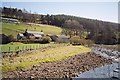
8
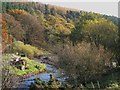
The River East Allen below Blackbank (2)
Image: © Mike Quinn
Taken: 31 Oct 2009
0.06 miles
9
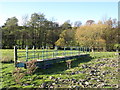
Footbridge over the River East Allen
Well, it used to be - see Image
Image: © Mike Quinn
Taken: 31 Oct 2009
0.06 miles
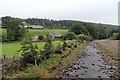
10
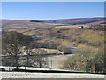
Frosty valley of the River East Allen below Broad Gate
Image: © Mike Quinn
Taken: 29 Jan 2011
0.06 miles