IMAGES TAKEN NEAR TO
Sinderhope, HEXHAM, NE47 9SH
Introduction
This page details the photographs taken nearby to NE47 9SH by members of the Geograph project.
The Geograph project started in 2005 with the aim of publishing, organising and preserving representative images for every square kilometre of Great Britain, Ireland and the Isle of Man.

There are currently over 7.5m images from over14,400 individuals and you can help contribute to the project by visiting https://www.geograph.org.uk
Image Map
Images are licensed for reuse under creativecommons.org/licenses/by-sa/2.0
Notes
- Clicking on the map will re-center to the selected point.
- The higher the marker number, the further away the image location is from the centre of the postcode.
Image Listing (10 Images Found)
Images are licensed for reuse under creativecommons.org/licenses/by-sa/2.0
Image
Details
Distance
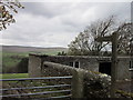
2
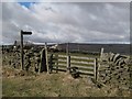
Footpath to Holms Linn
The building in the distance (above the left hand side of the gate) is the Image
Image: © Mike Quinn
Taken: 25 Mar 2009
0.07 miles

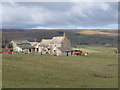
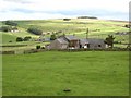
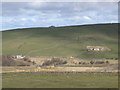
4
Farm at Sinderhope
Looking east of north towards the Image
Image: © Mike Quinn
Taken: 25 Mar 2009
0.12 miles
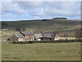
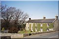
5
Shoppe House and the Valley of the Hollocks Burn
A tributary of the East Allen. Sinderhope Burnfoot lies in the floor of the valley to the left. The farm on the far side of the valley on the left hand side is Garret's Hill.
Image: © Oliver Dixon
Taken: 26 Sep 2007
0.13 miles
6

Visitors Not Welcome!
The dried-out remains of 15 moles suspended from a fence on the B6295. Whether to scare off further visitations by such, or to nauseate passing tourists?
Image: © Barry Boxer
Taken: 23 Oct 2009
0.15 miles
9
East Allen Dale at Sinderhope (2)
Looking west of north across the valley from near the Image The building on the left is the Image (photo by Bill Cresswell); that on the right is Image (photo by Helen Wilkinson).
Image: © Mike Quinn
Taken: 25 Mar 2009
0.22 miles
10
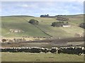
East Allen Dale at Sinderhope
Looking north from near the Image The small cottage in the valley is that in Image; on the far side of the valley, the farm on the left is Image (photo by Helen Wilkinson) and that on the right is Image
Image: © Mike Quinn
Taken: 25 Mar 2009
0.23 miles