IMAGES TAKEN NEAR TO
Sinderhope, HEXHAM, NE47 9SB
Introduction
This page details the photographs taken nearby to NE47 9SB by members of the Geograph project.
The Geograph project started in 2005 with the aim of publishing, organising and preserving representative images for every square kilometre of Great Britain, Ireland and the Isle of Man.

There are currently over 7.5m images from over14,400 individuals and you can help contribute to the project by visiting https://www.geograph.org.uk
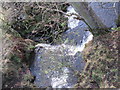
Image Map
Images are licensed for reuse under creativecommons.org/licenses/by-sa/2.0
Notes
- Clicking on the map will re-center to the selected point.
- The higher the marker number, the further away the image location is from the centre of the postcode.
Image Listing (106 Images Found)
Images are licensed for reuse under creativecommons.org/licenses/by-sa/2.0
Image
Details
Distance
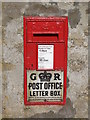
1

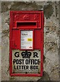
Refurbished George V "Ludlow" postbox at Sinderhope
The box was refurbished in 2018 - see Image I think that the door has been replaced, and now has a long hinge on its right hand side. Although the original enamel "GR Post Office Letter Box" plate has been re-used, it has been trimmed slightly along each side and at the bottom. I don't understand why they didn't paint the screw heads and the door hinge red.
The location of the postbox is shown in Image
Image: © Mike Quinn
Taken: 21 Jun 2019
0.01 miles
2
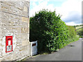
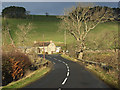
(Part of) the former Post Office at Sinderhope
Shows the location of Image
Image: © Mike Quinn
Taken: 21 Jun 2019
0.01 miles
3
George V "Ludlow" postbox at Sinderhope
No more collections on Sundays - see Image (photo by Bill Cresswell). The location of this postbox is shown in Image and Image
Image: © Mike Quinn
Taken: 19 Mar 2009
0.01 miles
4
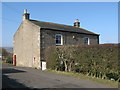
The former Post Office at Sinderhope
Image: © Mike Quinn
Taken: 19 Mar 2009
0.02 miles
5
Sinderhope Post Box
Good example of a 'GR' Letter Box at Sinderhope.
Image: © Bill Cresswell
Taken: 1 Nov 2006
0.03 miles
6
The B6295, Sinderhope
The bridge at the confluence of Sinderhope and Hollocks Burns.
Image: © Andrew Smith
Taken: 21 Dec 2006
0.03 miles
7
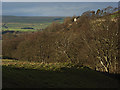
Sinderhope
Trees beside Sinderhope Burn and the old chapel (http://www.geograph.org.uk/photo/274361 ).
Image: © Andrew Smith
Taken: 21 Dec 2006
0.03 miles
8
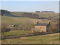
East Allen Dale at Sinderhope (3)
The building with the red door is Image
Image: © Mike Quinn
Taken: 19 Mar 2009
0.03 miles
9
Bridge carrying the B6295 over Sinderhope Burn
Image: © Mike Quinn
Taken: 25 Mar 2009
0.04 miles